Historical Publications of the Charles River Basin
As part of the due diligence for this project, we have collected various charts, maps, and reports that have been generated for areas in the Lower Charles River Basin in the past. Below is a list in approximate chronological order.
- Charts of the Charles River
- USGS Reports
- EPS Reports
- Other Reports
- Related Books
- Charts of the Boston Harbor
- Maps of Surrounding Land
- Sources of Maps and Charts
Historical Charts of the Charles River
- A Plan of Boston in New England with its environs, Henry Pelham, 1777
- Chart of Boston Harbour, Alexander S. Wadsworth, 1819
- Plan of the Harbour of Boston (Charles River), Massachusetts Harbor Commissioners, 1839
- Plan of Charles River to the head of tide waters, Massachusetts Harbor Commissioners, 1846
- Boston Harbor, U.S. Coast Survey, 1857
- Comparative Map of Boston Harbor, U.S. Coast Survey, 1860
- Boston Harbor, U.S. Coast Survey, 1863
- Boston Harbor, U.S. Coast Survey, 1867
- Compiled Plan, Showing Millers Creek and a Portion of Charles River, E.F. Bowker, 1873
- Boston Harbor, U.S. Coast Survey, 1878
- Charles River, West Boston Bridge to Navy Yard, Board of Harbor and Land Commissioners of Massachusetts, 1882
- Sketch of Charles River, U.S. Corp of Army Engineers, 1884
- Charles River, North Beacon Street to Brookline Street Bridge, U.S. Harbor Line Board, 1888
- Charles River, Brookline Street Bridge to Boston Harbor, U.S. Harbor Line Board, 1888
- Charles River, Brookline Street Bridge to Charles River Bridge, Massachusetts Harbor and Land Commissioners, 1888
- Boston Harbor, Mass. Map of Charles River: From Brookline Street Bridge to Charles River Bridge, U.S. Harbor Line Board, 1889
- Boston Harbor, Mass. Map of Charles River: From Brookline Street Bridge to its mouth, U.S. Harbor Line Board, 1890
- Charles River, Brookline Street Bridge to its Mouth, U.S. Harbor Line Board of 1888, 1890
- Plan of the Charles River from the Waltham line to Boston Harbor, Metropolitan Park Commission and the State Board of Health, 1894
- Boston Inner Harbor, US Coast and Geodetic Survey, 1897
- Charles River Basin Contour Map of Upper Basin, Watertown Dam to nearly Arsenal Street, Committee on the Charles River Dam, 1902
- Charles River Basin Contour Map of Lower Basin, Arsenal Street to River Street, Committee on the Charles River Dam, 1902
- Charles River Basin Contour Map of Lower Basin, River Street to the Craigie Bridge, Committee on the Charles River Dam, 1902
- Lechmere Canal, Committee on the Charles River Dam, 1902
- Broad Canal, Committee on the Charles River Dam, 1902
- Boston Inner Harbor, US Coast and Survey, 1903
- Proposed New Channel near Longfellow Bridge, Cambridge Bridge Commission, 1903
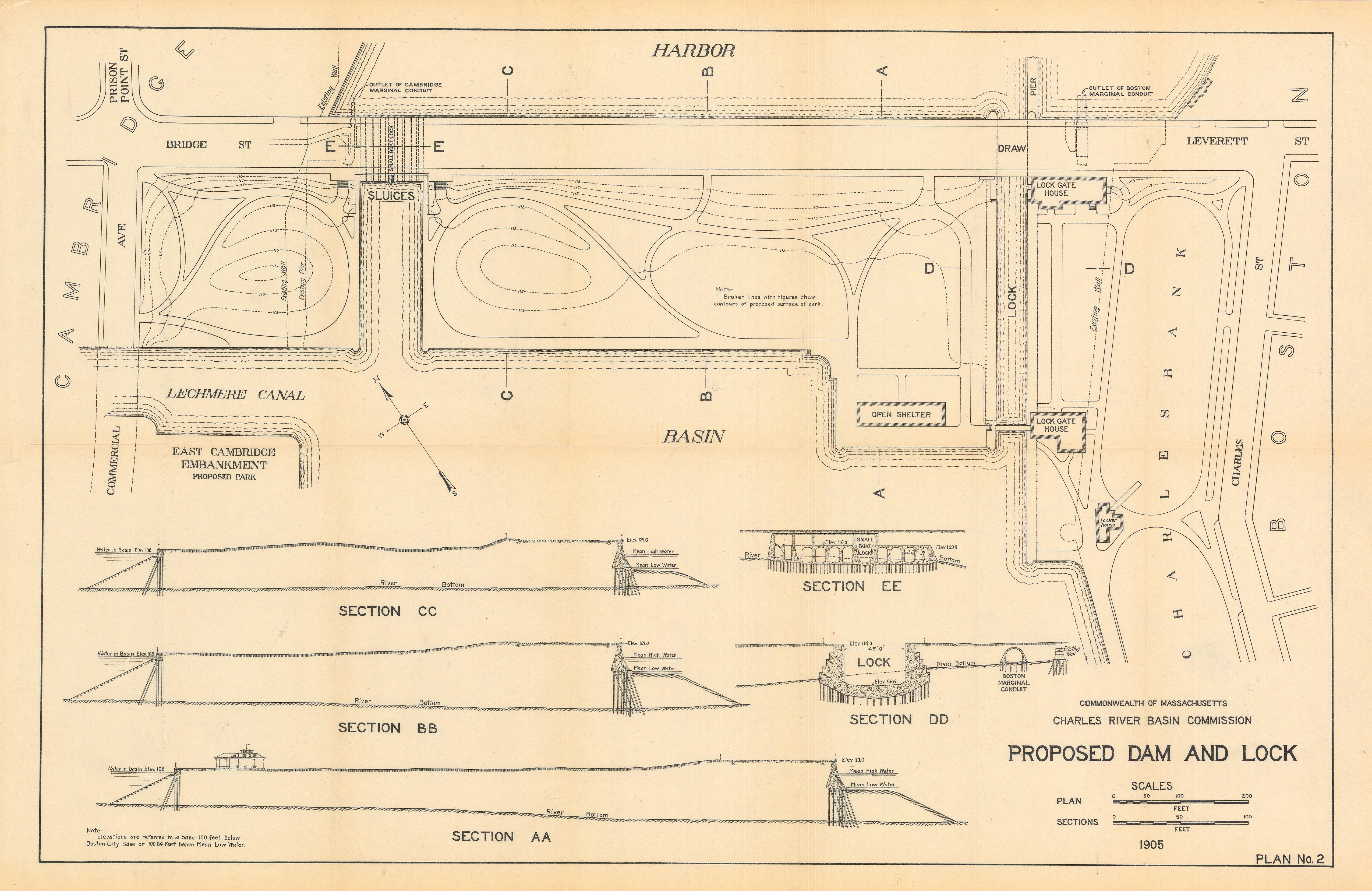
- Proposed Dam and Lock, Charles River Basin Commission, 1905
- Charles River, Bridges of the Boston and Maine Railroad, U.S. Engineer Office, Boston, Mass., 1906
- Proposed Dredging between North Beacon St and Galen St, Metropolitan Park Commission, 1913
- Proposed Fill in Charles River, Metropolitan District Commission, 1928
- Cottage Farm Bridge to Dam, Location and Profile of Borings [Sheet 1] [Sheet 2] [Sheet 3], Metropolitan District Commission, 1930
- Dredging near Charlesgate East [Sheet 1] [Sheet 2], Metropolitan District Commission, 1946
- Constructions Plans of the Eliot Bridge, Burns and Kenerson, Inc., 1949
- Charles River Dam and Adjacent Estuary [Sheet 1] [Sheet 2], Metropolitan District Commission, 1958
- Plan for Dredging Charles River Fanueil Valley Brook Outlet, Metropolitan District Commission, 1965
- New Charles River Dam, General Plan, U.S. Army Corp of Engineers, 1973
- New Charles River Dam, Final River Grading, U.S. Army Corp of Engineers, 1973
- Charles River Cross-sections [Sheet 1] [Sheet 2] [Sheet 3] [Sheet 4] [Sheet 5], Metropolitan District Commission, 1976
- Charles River & Fanueil Brook, Metropolitan District Commission, 1976
- Charles River & Fanueil Brook Cross-sections [Sheet 1] [Sheet 2] [Sheet 3] [Sheet 4] [Sheet 5], Metropolitan District Commission, 1976
- Charles River Lower Basin, Charles River Destratification Plan, Metropolitan District Commission, 1976
- Water depths, thickness of post-1908 sediment, and sediment sampling locations, lower Charles River (PDF [15 MB], JPG [52 MB]) from USGS Water-Resources Investigations Report 2000-4180, U.S. Army Corp of Engineers, 2000
- Depth Chart, Old Charles River Dam to Harbor, Democratic National Convention, U.S. Army Corp of Engineers, 2004
- Charles River Soundings near BWSC Outfall 032 [? Fanueil Brook outlet], Massachusetts Department of Conservation and Recreation, 2011
![JPG [52 MB]](chart_archive/USGS/USGS-Lower-Charles-River-depth-map-2000-00-4180.jpg)
USGS Reports
- Muddy River Flood Damage Reduction and Ecosystem Restoration Project, 2013
- A multi-metric assessment of environmental contaminant exposure and effects in an urbanized reach of the Charles River near Watertown, Massachusetts
Open-File Report 2012-1195, 2012 - Simulated Effects of Year 2030 Water-Use and Land-Use Changes on Streamflow near the Interstate-495 Corridor, Assabet and Upper Charles River Basins, Eastern Massachusetts
Scientific Investigations Report 2008-5132, 2008 - The Charles River, Eastern Massachusetts: Scientific Information in Support of Environmental Restoration
General Information Product 47, 2007 - Water resources and the urban environment, lower Charles River watershed, Massachusetts, 1630-2005
Circular 1280, 2007 - Comparison of methods for determining streamflow requirements for aquatic habitat protection at selected sites on the Assabet and Charles Rivers, Eastern Massachusetts, 2000-02
Scientific Investigations Report 2004-5092, 2004 - Evaluation of Strategies for Balancing Water Use and Streamflow Reductions in the Upper Charles River Basin, Eastern Massachusetts
Water-Resources Investigations Report 2003-4330, 2003 - Testing ground-water-management alternatives in the Upper Charles River basin, eastern Massachusetts
Fact Sheet 042-03, 2003 - Simulation of ground-water flow and evaluation of water-management alternatives in the upper Charles River basin, eastern Massachusetts
Water-Resources Investigations Report 2002-4234, 2002 - Potential effects of structural controls and street sweeping on stormwater loads to the lower Charles River, Massachusetts
Water-Resources Investigations Report 2002-4220, 2002 - Streamflow, Water Quality, and Contaminant Loads in the Lower Charles River Watershed, Massachusetts, 1999–2000
Water-Resources Investigations Report 2002-4137, 2002 - Measured and simulated runoff to the lower Charles River, Massachusetts, October 1999-September 2000
Water-Resources Investigations Report 2002-4129, 2002 - Preliminary assessment of streamflow requirements for habitat protection for selected sites on the Assabet and Charles rivers, eastern Massachusetts
Open-File Report 2002-340, 2002 - Spatial distribution, temporal variability, and chemistry of the salt wedge in the lower Charles River, Massachusetts, June 1998 to July 1999
Water-Resources Investigations Report 2000-4124, 2000 - Distribution and potential for adverse biological effects of inorganic elements and organic compounds in bottom sediment, lower Charles River, Massachusetts
Water-Resources Investigations Report 2000-4180, 2000 - Water resources and aquifer yields in the Charles River basin, Massachusetts
Water-Resources Investigations Report 88-4173, 1988 - Aerial profiling of terrain system (APTS) applications test report; Charles River Project
Open-File Report 85-302, 1985 - Hydrology and water resources of the Charles River basin, Massachusetts
Hydrologic Atlas 554, 1975 - Hydrology and water resources of the Charles River basin, Massachusetts
Open-File Report 74-241, 1974 - Ground-water management, Charles River basin, Massachusetts
Open-File Report 73-77, 1973 - Flood of March 1968 on the Charles River, Massachusetts
Hydrologic Atlas 419, 1971
EPA Reports
- Sustainable Stormwater Funding Evaluation for the Upper Charles River Communities of Bellingham, Franklin, and Milford, MA, Appendix A, 2011
- Stormwater Funding for the Upper Charles River Communities, 2011
- Draft Residual Designation Permit, 2010
- Optimal Stormwater Management Plan Alternatives: A Demonstration Project in Three Upper Charles River Communities, 2009
- Preliminary Residual Designation for Charles River, 2008
- Lower Charles River Basin Nutrient (Phosphorus) TMDL, 2007
- 10 Year Report on the Clean Charles 2005 Initiative, 2005
- Results of Color and Clarity Monitoring in the Charles River During Spring and Summer of 2000, 2003
- Charles River Fish Contaminant Survey, 2001
- Charles River Water Quality Survey, 1998
- Charles River Sediment/Water Quality Analysis Project Report, 1997
- Water Quality Reports on the Lower Charles River
- Live Water Quality Data
- 2007-2008 EPA Water Quality Report on the Lower Charles River
- 2006 EPA Water Quality Report on the Lower Charles River
- 2005 EPA Water Quality Report on the Lower Charles River
- 2004 EPA Water Quality Report on the Lower Charles River
- 2003 EPA Water Quality Report on the Lower Charles River
- 2002 EPA Water Quality Report on the Lower Charles River
- 2001 EPA Water Quality Report on the Lower Charles River
- 2000 EPA Water Quality Report on the Lower Charles River
- 1999 EPA Water Quality Report on the Lower Charles River
- 1998 EPA Water Quality Report on the Lower Charles River
MIT Reports
- Lower Charles River Bathymetry: 108 Years of Fresh Water, Senior Undergraduate Thesis, Madonna K. Yoder, MIT, 2017
Appendix 1, Appendix 2 - The Use of Turbulent Jets to Destratify the Charles River Basin, Masters Degree Thesis, Jeffrey H. Church, MIT, 2012
- Remote Depth Survey of the Charles River Basin, Senior Undergraduate Thesis, Evan A. Karlik, MIT, 2007
Other Reports
- MMOC Muddy River Restoration Project
- Evolution Over the Life Span of Complex Systems,
from "Global Product Development: Proceedings of the 20th CIRP Design Conference", 2011.
The report discusses water quality in "the tidal basin before 1910 and the construction of the first dam, the original Charles River Dam, the new Charles River Dam as it was originally intended, and the current state of the basin without a functioning bubbler system." - Excerpt from Users of the Water Sheet, Bathymetry and Aquatic Vegetation in the Charles River Basin, Findings, Figures, Cortell Associates for MDC, 1997
- Charles River Lower Basin Study US Environmental Protection Agency, 1976
- Charles River Destratification Report, Metropolitan District Commission, 1981
- Annual Reports of the Charles River Basin Commission, 1st, 2nd, 3rd, 4th, 5th, via Hathitrust, 1903-07
- Annual Reports of the Charles River Basin Commission, 6th, 7th, Final, via Hathitrust, 1908-10
- Final Report of the Charles River Basin Commission, 1910
- Seventh Annual Report of the Charles River Basin Commission, 1909
- Sixth Annual Report of the Charles River Basin Commission, 1908
- Fifth Annual Report of the Charles River Basin Commission, 1907
- Fourth Annual Report of the Charles River Basin Commission, 1906
- Third Annual Report of the Charles River Basin Commission, 1905
- Second Annual Report of the Charles River Basin Commission, 1904
- First Annual Report of the Charles River Basin Commission, 1903
- Report of the Committee on Charles River Dam, 1903
- Evidence and Arguments Before the Committee on the Charles River Dam, 1903
- The Improvement of the Charles River Basin, 1901
Related Books
- Remaking Boston: An Environmental History of the City and Its Surroundings edited by Anthony N. Penna and Conrad Edick Wright, University of Pittsburgh Press, 2009
- Boston's Back Bay, The Story of America's Greatest Nineteen-Century Landfill Project by William A. Newman and Wilfred E. Holton, Northestern University Press, 2006
- Gaining Ground: A History of Landmaking in Boston by Nancy Seasholes, The MIT Press, 2003
- Inventing the Charles River, Karl Haglund, The MIT Press, 2002
- Mapping Boston by Alex Krieger and David Cobb, The MIT Press, 1999
Historical Charts of the Boston Harbor
- The South part of New-England, as it is Planted this year, 1639, William Wood, 1634
- This Harbour of Boston, Phillip Wells, 1688
- Boston Harbour in New England, John Seller, 1689
- A Draught of Boston Harbor, Cyprian Southack, 1694
- A New Survey of the Harbour of Boston in New England, done by order of the principall officers and comissioners of Her Majesty's Navy, 1708
- An Exact Draught of Bostone harbour, with a Survey of most of the Islands about it, Cyprian Southack, 1711
- Boston Harbour, From Atlas maritimus et commercialis, James and John Knapton, 1728
- A Large Draught of New England, New York and Long Island, from a pirated Dublin edition of The English Pilot, 1749
- Baye et Port de Boston , Georges-Louis Le Rouge, 1756
- Carta rappresentante il porto di Boston, Giuseppe Maria Terreni, 1763
- Carte de la Baye de Baston, Jacques Nicolas Bellin, 1764
- A new and accurate plan of the town of Boston in New England : A new plan of Boston Harbor from an actual survey, John Hinton, 1774
- A chart of the harbour of Boston, Joseph F.W. Des Barres and George Callender, 1775
- A plan of the town and chart of the harbour of Boston exhibiting a view of the islands, castle forts, and entrances into the said harbour, 1775
- A new and correct plan of the town of Boston, Thomas Hyde Page, 1775
- A new and correct plan of the town of Boston, and provincial camp, Robert Aitken, 1775
- A Plan of the Town and Harbour of Boston, Charles Hall, 1775
- A New Plan of Boston Harbour from an Actual Survey, Caleb Lownes, 1775
- A Plan of the Town and Harbour of Boston, J. De Costa, 1775
- A Plan of the Bay and Harbor of Boston, Thomas Wheeler, 1775?
- Boston & harbour, unknown source, 1775?
- A Plan of Boston and its Environs, shewing the true situation of His Majesty's army, and also those of the rebels, Richard Williams, 1776
- A Chart of the Harbour of Boston, with the soundings, sailing-marks, and other directions, Robert Sayer and John Bennett, 1776
- A Chart of the Harbour of Boston, with the soundings, sailing-marks, and other directions, Robert Sayer and John Bennett, 1776
- Carte du port et havre de Boston avec les côtes adjacentes, dans laquel on a tracée les camps et les retranchemens occupé, tant par les Anglois que par les Américains, Jean de Beaurain, 1776
- Carte von dem Hafen und der Stadt Boston, George Friederich Jonas Frentzel, 1776
- A Plan of Boston in New England with its environs, Henry Pelham, 1777
- Boston, its Environs and Harbour, with the Rebel Works, Thoams Hyde Page, 1777
- Plan de Boston, George Louis Le Rouge, 1778
- Carte particuliere du havre de Boston, Joseph Bernard Chabert, 1780
- Boston Harbour, from Charts of the coast and harbors of New England [Atlantic Neptune], Joseph F.W. Des Barres and George Callender, 1781
- Puerto del Boston, Joseph del Campo, 178?
- A Chart of the Harbour of Boston, with the soundings, sailing-marks and other directions, Robert Laurie and James Whittle, 1800
- Plano de la bahia y puerto de Boston, Dirección de Hidrografía de Espana, 1809
- Chart of Boston Harbour, Alexander S. Wadsworth, 1819
- Chart of Boston Harbour, Alexander S. Wadsworth, 1819
- Plan of the Harbour of Boston (Charles River), Massachusetts Harbor Commissioners, 1839
- Boston Harbour from the survey of A.S. Wadsworth, Esq., U.S.N. and the chart of Des Barres, Edmund Blunt, 1847
- Plan of the Inner Harbor of Boston, U.S. Coast Survey, 1847
- A Chart exhibiting the normal course & Velocity of the Tidal Current at Ebb in Boston Harbor U.S. Coast Survey, 1848
- Map of Boston Harbor, showing commissioner's line, wharves, etc, Ellis Sylvester Chesbrough, 1852
- Map of parts of Boston Harbor and its Tributaries, U.S. Coast Survey, 1854
- Plan of South Bay showing the Harbor Commissioners lines, Board of Harbor Commissioners, 1854
- Sketch of Boston Harbor and Bay, U.S. Coast Survey, 1856
- Boston Harbor, U.S. Coast Survey, 1857
- Boston Harbor, from William Faden's Catalogue, John Hills, 1862
- Boston Harbor, U.S. Coast Survey, 1863
- Chart of Boston Harbor and Massachusetts Bay E.P. Dutton & Co., 1865
- Boston Harbor, U.S. Coast Survey, 1867
- Boston Harbor, U.S. Coast Survey, 1878
- Boston Harbor, U.S. Coast Survey, 1878
- Eldridge's New Chart of Boston Harbor, George Eldridge, 1884
- Boston Bay and Harbor, Boston Parks and Recreation Department, 1888
- Boston Harbor, Massachusetts, U.S. Coast and Geodetic Survey, 1889
- Map of Mystic River and Chelsea Creek, U.S. Harbor Line Board, 1890
- Map of Boston Harbor Harbor and Land Commissioners of Massachusetts, 1895
- Boston Inner Harbor, Massachusetts, U.S. Coast and Geodetic Survey, 1897
- Boston Inner Harbor, U.S. Coast and Geodetic Survey, 1897
- Boston Harbor, Massachusetts, U.S. Coast and Geodetic Survey, 1901
- Boston Harbor, Massachusetts, U.S. Coast and Geodetic Survey, 1906
- Boston Harbor & Vicinity, Directors of the Port of Boston, 1913
- U.S. Coast and Survey, 1875, 1889, 1899 missing
- Plan d'une partie de la rade de Boston pour faire connaitre le dispositif de ses deffenses, 1778
- Map of Boston harbor showing islands, shoals, channels, buoys, lighthouses, and ledges from Nahant to Minot's Light, W.M. Tenney & Co., 1885
- Boston Harbor and Surroundings. A Descriptive and Historical Sketch., Peleg Aborn, 1885 booklet with two maps
Surrounding Land
- Boston Over Time : filling in the land 1630 - present
- The Town of Boston in New England, John Bonner, 1722
- This Plan of Boston in New England, William Burgis, 1728
- A New Plan of ye Great Town of BOSTON in New England in AMERICA, William Price, 1739
- A New Plan of ye Great Town of BOSTON in New England in AMERICA with the many Additionall Buildings & New Streets to the Year, William Price, 1739 or 1743
- Plan de Boston, Georges-Louis Le Rouge, 1755
- Plan de la ville de Boston et ses environs, Abbe Prevost, 1757
- A plan of the town of Boston, in New-England, distinguishing that part which was burnt in 1760, from Royal Female Magazine, 1760
- Plan de la Ville et du Port de Boston, Jacques Nicolas Bellin, 1764
- A new and accurate plan of the town of Boston in New England : A new plan of Boston Harbor from an actual survey, John Hinton, 1774
- Exact plan of General Gage's lines on Boston Neck in America, Thomas Walker, 1775
- The Seat of War in New England, Robert Sayer and John Bennet, 1775
- A Plan of the Town and Harbour of Boston, Charles Hall, 1775
- A Plan of Boston from Actual Survey, Osgood Carleton, 1796
- A Plan of the Town of Boston, with the Intrenchments of His Majesty's Forces in 1775, Thomas Page, 1777
- Boston and its Environs, Richard Phillips, 1806
- Boston and its Environs, Caleb Parry Wayne, 1806
- Map of Boston in the State of Massachusetts, John G. Hales, 1814
- A Plan of Boston Comprising a Part of Charlestown and Cambridgeport, William B. Annin and George C. Smith, 1826
- The Town of Boston in New England, updated 1835
- A new and complete Map of the City of Boston with part of Charlestown, Cambridge, & Roxbury, Nathaniel Dearborn, 1839
- A new and complete Map of the City of Boston with part of Charlestown, Cambridge, & Roxbury, Nathaniel Dearborn, 1841
- A new and complete Map of the City of Boston with part of Charlestown, Cambridge, & Roxbury, Nathaniel Dearborn, 1846
- Plan of the City of Charlestown, Felton and Parker, 1848
- A new and complete Map of the City of Boston and Precints including part of Charlestown, Cambridge, & Roxbury, Nathaniel Dearborn, 1850
- Copy of a Plan of South Bay Board of Harbor Commissioners, 1850
- Map of the city of Boston and immediate neighborhood, Henry McIntyre, 1852
- Map of the city of Boston, Massts, I Slater and B. Callan, 1852
- Plan of Boston Comprising a Part of Charlestown and Cambridge, George G. Smith, 1857
- Plan of Boston, James Slade, 1862
- New Boston and Charles River Basin, Charles Davenport, 1874
- Map of the City of Boston, and it's Environs Griffith M. Hopkins &Co., 1874
- City of Boston Improved Sewerage, Boston City Council, 1877
- Plan Showing the Principal Portion of Boston from the latest authorities, Boston Map Company, 1880
- Plan of East Boston Thomas Wood Davis, 1880
- Plan of Boston, sa muel Augustus Mitchell, 1883
- Map of the Metropolitan District of Boston, Massachusetts, Charles Eliot, 1893
- 1630 Shoreline, Massachusetts Metropolitan Planning Organization, 2011
- Historical Urban Atlases of Boston at the Boston Public Library
- A new and complete Map of the City of Boston and Precints including part of Charlestown, Cambridge, & Roxbury, Nathaniel Dearborn, 1835 missing yet
- Plan of the City of Boston and territory thereunto belonging, John G. Hales, 1830
- Plan of Boston with additions and corrections, Thomas Wood Davis, 1870. ?digital image ?
Sources of Digital Maps and Charts
While copies of the maps and charts listed above may exist in many places, we have tried to cite them using local repositories that have a physical copy.
- Norman B. Leventhal Map Center
- Digital Commonwealth
- Massachusetts State Library
- Massachusetts Department of Conservation and Recreation Archive
- Library of Congress
- The Boston Atlas, overlays of many historical maps and satellite photos
- NOAA Photo Library
- NOAA Office of Coast Survey Historical Map & Chart Collection