Historical Maps of Boston and Environs
As part of the due diligence for this project, we have collected various charts, maps, and reports that have been generated for areas in the Lower Charles River Basin in the past. In the sidebar to the right, there are several sets of documents in approximate chronological order. There is also a Google Drive spreadsheet that is more extensive.
While this is an extensive list of maps of Boston and the surrounding area, especially before 1850, it is not intended to be an exhaustive list. Many more maps can be found at places such as the Norman B. Leventhal Map Center and elsewhere.
- New England, first accurate depiction of MA and ME coastline, John Smith, 1624
- Map of Shawmut or Boston 1630 : at the time of settlement by the Winthrop Colony, [reconstructed from historical data], Samuel C. Clough, 19??
- Plan of Boston showing existing ways and owners on December 25, 1630, [reconstructed from historical data], George Lamb, 1903
- Plan of Boston showing existing ways and owners on December 25, 1630, George Lamb, 1903
- Shawmut or Trimountain 1630, in The Crooked & Narrow Streets of the Town of Boston 1630-1822, Annie Haven Thwing, 1920
- Plan of Boston showing existing ways and owners on December 25, 1631, [reconstructed from historical data], George Lamb, 1903
- Plan of Boston showing existing ways and owners on December 25, 1632, [reconstructed from historical data], George Lamb, 1903
- Plan of Boston showing existing ways and owners on December 25, 1633, [reconstructed from historical data], George Lamb, 1903
- Plan of Boston showing existing ways and owners on December 25, 1634, [reconstructed from historical data], George Lamb, 1903
- The South part of New-England, as it is Planted this year, 1639, earliest map showing Massachusetts settlements, William Wood, 1634
- New England, John Smith, 1635
- Plan of Boston showing existing ways and owners on December 25, 1635, [reconstructed from historical data], George Lamb, 1928
- Plan of Boston showing existing ways and owners on December 25, 1635, [reconstructed from historical data], George Lamb, 1903
- Plan of Boston showing existing ways and owners on December 25, 1635, George Lamb, 1903
- Plan of Boston showing existing ways and owners on December 25, 1636, [reconstructed from historical data], George Lamb, 1903
- Plan of Boston showing existing ways and owners on December 25, 1637, [reconstructed from historical data], George Lamb, 1903
- Plan of Boston showing existing ways and owners on December 25, 1638, [reconstructed from historical data], George Lamb, 1903
- Plan of Boston showing existing ways and owners on December 25, 1639, [reconstructed from historical data], George Lamb, 1903
- Map A or Map 1 being a combined map showing the separate sections which compose G. Lamb's Map of Boston according to the Book of Possessions, 1870
- Old Boston, compiled from the Book of possessions, George Lamb, 1881
- Old Boston, compiled from the Book of possessions, George Lamb, 1881
- Plan of Boston showing existing ways and owners on December 25, 1640, [reconstructed from historical data], George Lamb, 1903
- Plan of Boston showing existing ways and owners on December 25, 1640, [reconstructed from historical data], George Lamb, 1903
- Plan of Boston showing existing ways and owners on December 25, 1641, [reconstructed from historical data], George Lamb, 1903
- Plan of Boston showing existing ways and owners on December 25, 1642, [reconstructed from historical data], George Lamb, 1903
- Plan of Boston showing existing ways and owners on December 25, 1643, [reconstructed from historical data], George Lamb, 1903
- Plan of Boston showing existing ways and owners on December 25, 1644, [reconstructed from historical data], George Lamb, 1903
- Plan of Boston showing existing ways and owners on December 25, 1645, [reconstructed from historical data], George Lamb, 1903
- Plan of Boston showing existing ways and owners on December 25, 1645, [reconstructed from historical data], George Lamb, 1903
- The Town of Boston About 1645 Showing the Street mentioned in the Book of Possessions, in The Crooked & Narrow Streets of the Town of Boston 1630-1822, Annie Haven Thwing, 1920
- Map of the Town of Boston 1648, [reconstructed from historical data], Samuel C. Clough, 1919
- A rough and inaccurate sketch of the streets of Boston as they are supposed to have been first laid out & the owners of the soil, from 1630 to 1650 or thereabouts, William Appleton, [1866]
- Boston, 1630 to 1675, The Original Topography and Early Settlement together with the present Shore Line" "The fainter lines show streets of 1880., George E. Waring, 1886
- Mapp of New England, John Seller, 1675
- Map of the Town of Boston 1676, [reconstructed from historical data], Samuel C. Clough, 1920
- A Map of New England, first map printed in the Americas, John Foster, 1677
- Pas-kaart vande zee kusten inde boght van Niew Engeland : tusschen de staaten Hoek en C. de Sable, One of the earliest charts showing George's Bank, appears in Van Keulen's De Niewe Groote Zee-Fakkel, Johannes van Keulen, 1683
- Carte de la Ville, Baye, et Environs de Boston, Jean Baptiste Louis Franquelin, 1693
- Map of Boston Peninsula and surrounding regions about 1700, in The Boylston Street Fishweir study [1942], Frederick Johnson, 1942
- Boston in 1772, From a map of The Town of Boston, in New England, by Capt. John Bonner. The fainter lines show streets of 1880., George E. Waring, 1886
- Map of Boston 1722, [reconstructed from historical data], Samuel C. Clough, 1900?
- Plan of Boston in 1722, Abel Bowen, 1722
- The Town of Boston in New England, First State, John Bonner, 1722
- The Town of Boston in New England, original, previously unrecorded state, John Bonner and William Price, 1723
- A New Plan of ye Great Town of Boston, 1725 Second State, John Bonner and William Price, 1725
- A New Plan of ye Great Town of Boston, 1725 Third State, John Bonner and William Price, 1725
- Reproduction of Burgiss' map of Boston, 1728, printed for the Bostonian Society, 1885, William Burgis, 1728
- This Plan of Boston in New England, based on Bonner 1722 map, William Burgis, 1728
- This Plan of Boston in New England, based on Bonner 1722 map, facsimile, William Burgis, 1728
- A New Plan of ye Great Town of Boston, no known copy of fourth state exists, John Bonner and William Price, 1732
- A New Plan of ye Great Town of Boston in New England in America, 1733 Fifth State, John Bonner and William Price, 1733
- A New Plan of ye Great Town of Boston in New England in America, 1733 Fifth State, John Bonner and William Price, 1733
- A plan of the town dock, formerly called Bendalls Dock, in Boston, with the buildings round & flats before it, James Blake, 1738
- A New Plan of ye Great Town of Boston in New England in America, 1739 Sixth State, John Bonner and William Price, 1739
- A New Plan of ye Great Town of Boston in New England in America, 1743 Seventh State, John Bonner and William Price, 1743
- [Bird's-eye view of Boston, Massachusetts, with two vignettes of Natives hunting], James Turner, 174?
- Map of the original allotments of land and the ancient topography of Watertown (proper), Henry Bond, 1751
- Plan de Boston, Georges-Louis Le Rouge, 1755
- Plan de la ville de Boston et ses environs, Abbe Prevost, 1757
- Grundriss von der Stadt Boston und ihren Gegenden, [1758]
- A New Plan of ye Great Town of Boston in New England in America, 1760 Eighth State, John Bonner and William Price, 1760
- A plan of the town of Boston, in New-England, distinguishing that part which was burnt in 1760, from Royal Female Magazine, 1760
- Plan de la ville de Boston, Jacques Nicolas Bellin, [1764]
- Plan De La Ville De Boston et ses environs, from Le petit atlas maritime, vol. 14, Paris, Jacques Nicolas Bellin, 1764
- Plan de la Ville et du Port de Boston, Jean Lattre, 1764
- Plan de la Ville et du Port de Boston, Jean Lattre, 1764
- A New Plan of ye Great Town of Boston in New England in America, 1769 Ninth State, John Bonner and William Price, 1769
- A new plan of ye great town of Boston in New England in America with the many additionall buildings & new streets, to the year, 1769, John Bonner and William Price, 1769
- A New and Accurate Plan of the Town of Boston in New England ; A New Plan of Boston Harbor from an Actual Survey, colorized version, John Hinton, 178?
- A new and accurate plan of the town of Boston in New England : A new plan of Boston Harbor from an actual survey, John Hinton, 1774
- Plan de la ville et du port de Boston capitale de la Nouvelle Angleterre, 1774
- [Plan of the Neck and Environs], 1775
- A map of 100 miles round Boston, The Gentleman's Magazine, 1775
- A new and correct chart of the coast of New England and New York with the adjacent parts of Nova Scotia and New Brunswick from Cape Sable to the entrance of Hudsons or North River, first published in 1775 in Des Barres's Atlantic Neptune, was the pre-eminent chart of Boston Harbor produced in the 18th century, Nathaniel Holland, 1775
- A new and correct plan of the town of Boston, Thomas Hyde Page, 1775
- A new and correct plan of the town of Boston, and provincial camp, Robert Aitken, 1775
- A Plan oe the British lines on Boston Neck, 1775?
- A Plan of the Action at Bunker Hill, on the 17th of June 1775, Between His Majesty's Troops, Under the Command of Major General Howe, and the Rebel Forces, with overlay flap, Thomas Page, 1775
- A Plan of the Action at Bunker Hill, on the 17th of June 1775, Between His Majesty's Troops, Under the Command of Major General Howe, and the Rebel Forces, without overlay flap, Thomas Page, 1775
- A Plan of the Town and Harbor of Boston and the Country adjacent with the Road from Boston to Concord Showing the Place of the late Engagement between the King's Troops & the Provincials, This map was the first graphic document to show the battles at Concord and Lexington and was the only map to show the movement of the British troops and the sites of the major skirmishes., I. De Costa, 1775
- A Plan of the Town and Harbour of Boston, Charles Hall, 1775
- A plan of the town and harbour of Boston, And the country adjacent with the road from Boston to Concord shewing the place of the late engagement between the King's troops & the provincals, together with the several encampments of both armies in & about Boston, J. De Costa, [1775]
- A sketch of the action between the British forces and the American provincials, on the heights of the peninsula of Charlestown, the 17th of June 1775, Thomas Jefferys & William Faden, 1775
- A sketch of the action between the British forces and the American provincials, on the heights of the peninsula of Charlestown, the 17th of June 1775, William Faden, 1775
- Boston and the Adjacent Country with the Stations of the British & Provincial Armies, 1775?
- Exact plan of General Gage's lines on Boston Neck in America, Thomas Walker, 1775
- Plan of Boston and Vicinity, 1775?
- Plan of the town of Boston with the attack on Bunkers-Hill in the peninsula of Charlestown, the 17th of June, 1775. Printed in "An impartial history of the war in America, between Great Britain and the United States ... Vol. I.", following p 256, R. Sayer & J. Bennett, 1775 "
- Situations plan der Englischen Armée vor und um Boston nebst der stellung der Americaner, [Revolutionary War battle plan of the area around Boston, drawn shortly after the Battle of Bunker Hill in June 1775. Shows Boston at the center, 3 British war ships, and the roads to Boston.], 1775"
- Sketch of the Action on the Heights of Charlestown, June 17th, 1775, between His Majesty's troops, under the command, of Major Genl. Howe, and a large body of American rebels, Henry De Berniere, [1818]
- Sketch of the Battle of Bunker Hill, Henry De Berniere, 1843
- The Seat of War in New England, by an American Volunteer with the Marches of the Several Corps sent by the Colonies Towards Boston. with the Attack on Bunkers-Hill, Robert Sayer and John Bennett, 1775
- The Seat of War in New England, by an American Volunteer with the Marches of the Several Corps sent by the Colonies Towards Boston. with the Attack on Bunkers-Hill, Robert Sayer and John Bennett, 1775
- Thirty-miles round Boston, M. Armstrong, 1775
- A chart of Boston Bay and vicinity., Joseph F. W. Des Barres, 1776?
- A map of forty miles north, thirty miles west, and twentyfive miles south of Boston including an accurate draft of the harbour and town, 1776
- A Plan of Boston, and its environs, shewing the true situation of His Majesty's army. And also those of the rebels, Andrew Dury, 1776
- A plan of the town of Boston and its environs, with the lines, batteries, and incampments of the British and American armies, Thomas Hyde Page, 1776
- An accurate map of the country round Boston in New England from the best authorities, with inset of A plan of Boston and Charlestown; from a drawing made in 1771., A. Hamilton, London printer, 1776
- An accurate map of the country round Boston in New England from the best authorities, with inset of A plan of Boston and Charlestown; from a drawing made in 1771. Color tinted, A. Hamilton, London printer, 1776
- Fort on Fort Hill in Boston, [1776?]
- Gen. Washington's Revolutionary campaign war map, A.O. Crane, [1875]
- Plan of Boston, and its environs, shewing the true situation of His Majesty's army, and those of the rebels, Richard Williams, 1776
- A plan of the town of Boston, with the intrenchments &c. of His Majestys forces in 1775, Thomas Hyde Page, 1777
- A Plan of the Town of Boston, with the Intrenchments of His Majesty's Forces in 1775, Thomas Page, 1777
- A Plan of the Town of Boston, with the Intrenchments of His Majesty's Forces in 1775, Thomas Hyde Page, 1777
- [Boston Harbour, with the surroundings, &c., John Hills, 177-
- Boston, Gerstmayr, 1780
- Boston, Gerstmayr, 1780
- Carte particulière du havre de Boston , Joseph Bernard, 1780
- Plan of the town of Boston, with the attack on Bunkers-Hill, in the peninsula of Charlestown, the 17th of June, 1775, John Norman, 1781
- A new chart of the coast of New England, Nova Scotia, and the islands of St. John, Cape Breton, Sable, Gerard van Keulen, 1784
- The coast of a part of New England, New York, New Jersey, Pensilvania, Maryland, Virginia, and part of North Carolina, Gerard van Keulen, 1784
- Manuscript map of the 1787 fire of Boston, Masssachusetts, Jeremy Belknap, 1787
- Plan of the Town of Boston, accompanying the first directory of Boston, 1789. [facsimile], John Norman, 1789
- Manuscript map of Boston, Jeremy Belknap, 1794
- A Plan of the Town of Boston, in the County of Suffolk, & Commonwealth of Massachusetts, Osgood Carleton, 1795
- A Plan of Boston from Actual Survey, Osgood Carleton, 1796
- A Plan of the Action at Breeds Hill*, on the 17th of June 1775. Between the American Forces, and The British Troops. *Erroneously called Bunkers Hill., Charles Smith, 1797
- An accurate plan of the town of Boston and its vicinity, Osgood Carleton, 1797
- Atlas of Boston neighborhoods based on the Direct Tax Census of 1798, [reconstructed from historical data], Samuel C. Clough, 1930-40
- Atlas of Boston neighborhoods based on the Direct Tax Census of 1798, Samuel Chester Clough
- Property Owners of the Town of Boston, Samuel Chester Clough
- A Plan of Boston from actual Survey, [published by George B. Foster, 1872], Osgood Carleton, 1872
- A plan of a survey of Noodle Island, William Taylor, 1801
- Boston, Plate 72 from Luffman's Select Plans, Vol. 2, John Luffman, 1802
- A Plan of Boston from actual Survey, in Boston Directory [John West, 1803]. 1901 Reproduction, Osgood Carleton, 1803
- Manuscript plan of South Boston, Mather Withington, 1804
- A Plan of Boston, from actual Survey, Osgood Carleton, 1805
- A Plan of Boston, from actual Survey, Osgood Carleton, 1805
- A plan of South Boston and the owners lands, and the roads, Mather Withington, 1805
- A New Plan of Boston, Drawn from the Best Authorities with the Latest Improvements, William Norman, William Pelham, 1806
- Boston and its Environs, Caleb Parry Wayne, 1806
- Boston and its Environs, Richard Phillips, 1806
- Manuscript plan of the Bulfinch Triangle, Boston, MA {sheet 1], Charles Bulfinch, 1807
- Manuscript plan of the Bulfinch Triangle, Boston, MA {sheet 2], Charles Bulfinch, 1807
- Plan of Boston, Osgood Carleton, 1807
- Plan of Boston, in Boston Directory [Edward Cotton, 1807], William Norman, 1807
- Plan of Boston, 1800-1807
- A Plan of the Mill Pond in Boston with the Parts adjacent Exhibiting the Streets, Canal, and Market, Charles Bulfinch, 1808
- A plan of Fort Independence, Lewis Packham, 1809
- Plan of Boston, in the Boston Directory, 1809, John Norman, 1809
- A plan of those parts of Boston, and the towns in its vicinity, with the waters and flats adjacent, which are immediately or remotely connected with the contemplated design of erecting perpetual tide-mills, Benjamin Dearborn, 1814
- A plan of those parts of Boston, and the towns in its vicinity, with the waters and flats adjacent, which are immediately or remotely connected with the contemplated design of erecting perpetual tide-mills, Benjamin Dearborn, 1814
- Back Bay in 1814, Fuller and Whitney, 1814
- Boston in 1814, From a map of Boston, in the State of Massachusetts, Surveyed by I.G. Hales". The fainter lines show streets of 1880., George E. Waring, 1886
- Map of Boston in the State of Massachusetts, John G. Hales, 1814
- Plan of Charlestown peninsula in the state of Massachusetts, Peter Tufts, 1818
- Map of Boston and its vicinity from actual survey, John G. Hales, 1819
- Map of Boston and its vicinity from actual survey, John G. Hales, 1820
- Maps of the Street-Lines of Boston, made for the Selectmen in 1819 and 1820, John G. Hales, 1894
- [Plan of the Mill Dam Project], in Survey of Boston and Its Vicinity, John G. Hales, 1821
- Plan of Boston, 1821-1822
- Plan of Boston, in the Boston Directory, 1821, John H.A. Frost and Charles Stimpson, Jr., 1821
- Plan of Boston, 1822-1825
- Section I. The North End, likely reconstructed in 1920, Annie Haven Thwing, 1822
- Section II. Government and Business Centre, likely reconstructed in 1920, Annie Haven Thwing, 1822
- Section III. Residential Part, likely reconstructed in 1920, Annie Haven Thwing, 1822
- Section IV. The West End, likely reconstructed in 1920, Annie Haven Thwing, 1822
- Section V. The Neck, likely reconstructed in 1920, Annie Haven Thwing, 1822
- Ground Plan of the [Quincy] Market House, S.P. Fuller, 1823
- Plan of Boston in 1824, published in Snow's History of Boston (1828), Caleb H. Snow, 1828
- Plan of Boston, in Boston Directory [John H.A. Frost and Charles Stimpson, 1825], Edward Cotton, 1825
- A Plan of Boston Comprising a Part of Charlestown and Cambridgeport, William B. Annin, George C. Smith, and J.V.N. Throop, 1826
- Plan of Boston comprising a part of Charlestown and Cambridgeport, [locked to Harvard only], William B. Annin and George G. Smith, 1826
- Sketch of Bunker Hill Battle, Samuel Swett, 1826
- Plan of Boston, 1826-1828
- Plan of Boston in 1828, 1828
- [Plan showing wharves of Boston from Batterymarch Street to Fleet Street and "the circular line" Barricado, with the south, middle and north gaps], Caleb Hopkins Snow, 1820-1829?
- Map of Boston and its vicinity from actual survey, John G. Hales, 1829
- Plan of the City of Boston, Charles Stimpson, 1829
- Water Privilege at Watertown Bridge, I Roby, 1829
- Plan of the City of Boston and territory thereunto belonging, John G. Hales, 1830
- A map of the towns of Dorchester and Milton, Edmund J. Baker, 1831
- Map of the Town of Roxbury, John G. Hales, 1832
- Plan of the City of Boston, Charles Stimpson, 1832
- Map of Boston and its vicinity : from actual survey..., with corrections in 1833, with colored outlines of counties, John G. Hales, 1833
- Map of Boston and its vicinity from actual surveys, John G. Hales, 1833
- Plan of sections of 1, 2 & 3, East Boston, Samuel Lewis, 1833
- Boston, Henry S. Tanner, 1834
- Plan of East Boston shewing the location of a mill dam and other improvements, Robert Henry Eddy, 1834
- Plan of the City of Boston, Charles Stimpson, 1834
- A new and complete Map of the City of Boston and Precincts including part of Charlestown, Cambridge, & Roxbury, Nathaniel Dearborn, 1835
- Plan of Boston Comprising a Part of Charlestown and Cambridge, George C. Smith, 1835
- Plan of Boston with parts of the adjacent towns, George W. Boynton, 1835
- Plan of Boston with parts of the adjacent towns, G.W. Boynton, 1835
- Plan of the City of Boston, Charles Stimpson, 1835
- South Cove, in Boston, Pendleton's Lithography, 1835
- The South Cove Territory, Pendleton's Lithography, 1835
- The Town of Boston in New England, 1835 redrawn from a copy of Third State, George G. Smith, 1835
- The Town of Boston In New England, 1835 redrawn from a copy of Third State, John Bonner and William Price, 1835
- The Town of Boston in New England, 1835 redrawn from a copy of Third State, George G. Smith, 1835
- Back Bay in 1836, Fuller and Whitney, 1836
- Plan of East Boston showing the land and water lots sold and unsold, also all buildings and other Improvements, Robert Henry Eddy, 1837
- Plan of the Harbor of Boston, B.F. Perham, Board of Harbor Commissioners, 1837
- Plan of the South Cove, 1837
- Boston, John Tallis, 1838
- Boston, Charles Stimpson, 1838
- Boston, George W. Boynton, 1838
- A New & Complete map of the city of Boston, with part of Charlestown, Cambridge & Roxbury, George W. Boynton for Nathaniel Dearborn & Son, 1839
- Boston, Henry S. Tanner, 1839
- Plan of the city of Boston, George W. Boynton, 1840
- A New & Complete map of the city of Boston, with part of Charlestown, Cambridge & Roxbury, George W. Boynton, 1841
- Boston, Thomas G. Bradford, 1841
- Boston Y Sus Aldredores - Boston Et Ses Environs, Alexandre Blondeau, 1841
- Plan of the city of Boston, George W. Boynton, 1841
- Boston, from Tanner, H.S. The American Traveller; or Guide Through the United States. Eighth Edition. New York, 1842, H.S. Tanner, 1842
- Boston with Charlestown and Roxbury, Benjamin Rees Davies, 1842
- Boston with Charlestown and Roxbury, Society for the Diffusion of Useful Knowledge, 1842
- Plan of the city of Boston, George W. Boynton, 1842
- Map of the Town of Roxbury, surveyed by order of the town authorities, Charles Whitney and George W. Boynton, [1843]
- Map of the Town of Roxbury, Charles Whitney, 1843
- Boston with Charlestown and Roxbury, Benjamin Rees Davies, [1844]
- General Plan for enlarging and improving the City of Boston, Robert Gourlay, 1844
- Plan of East Boston showing the land and water lots and other Improvements, Robert Henry Eddy, 1844
- Plan of the City of Boston, George W. Boynton, 1844
- A New & Complete Map of the City of Boston with part of Charlestown, Cambridge, & Roxbury, George W. Boynton for Nathaniel Dearborn, 1846
- Boston, Henry S. Tanner, 1846
- Plan of Boston comprising a part of Charlestown and Cambridge, updated version of 1826 Annin and Smith and 1835 Smith maps, more accurate than 1848 Dearborn map, George G. Smith, 1846
- A new and complete Map of the City of Boston and Precincts including part of Charlestown, Cambridge, & Roxbury, Nathaniel Dearborn, 1848
- Plan of Boston With Parts of East and South Boston, Also Portions of Charlestown and Cambridge, W. Williams, 1848
- Plan of the City of Charlestown, Felton and Parker, 1848
- Boston with its Environs, 1775 & 1776, from History of the siege of Boston, and of the battles of Lexington, Concord, and Bunker Hill, Richard Frothingham, 1849
- Map of the Town of Roxbury, Charles Whitney, 1849
- Map of the Vicinity of Boston, George W. Boynton, 1849
- Plan of Boston and its vicinity showing the connection of the Grand Junction Rail Road with the Harbor and other Rail-roads, Tappan & Bradford, 1840-1849
- Plan of Chelsea Creek between East Boston and Chelsea exhibiting the circumscribing line to which wharves may be extended, Harbor Commissioners, 1849
- A new and complete Map of the City of Boston and Precincts including part of Charlestown, Cambridge, & Roxbury, Nathaniel Dearborn, 1850
- Bird's eye view of Boston, John Bachmann, 1850
- Bird's eye view of Boston, John Bachmann, 1850
- Copy of a Plan of South Bay, Board of Harbor Commissioners, 1850
- Map of Dorchester Mass., Elbridge Whiting, 1850
- Back Bay in 1851, Fuller and Whitney, 1851
- New map of Boston, comprising the whole city, with the new boundaries of the wards, George W. Boynton, 1851
- Plan of Boston comprising a part of Charlestown and Cambridge, George G. Smith, 1851
- Plan of East Boston showing the land and water lots sold and unsold, also all buildings and other Improvements, Robert Henry Eddy, 1851
- [Plan of Boundary Lines in Roxbury and the City of Boston], Stephen P. Fuller, Board of Harbor and Land Commissioners of Massacusetts, 1852
- A Plan of the Salt Marsh and Upland in Roxbury, Lying on the East Side of the Mill Creek, from Massachusetts Senate document No. 45, 1852, Simon Greenleaf & Joel Giles, 1852
- Map of Somerville, Mass, Martin Draper, 1852
- Map of the city and vicinity of Boston Massachusetts, James C. Sidney, 1852
- Map of the city of Boston and immediate neighborhood, Henry McIntyre, 1852
- Map of the city of Boston, Massts, I. Slatter and B. Callan, 1852
- New map of Boston, comprising the whole city, with the new boundaries of the wards, George W. Boynton, 1852
- Plan of Back Bay and Vicinity, Henry F. Conant, 1852
- Plan presented to the honble. the State Commissioners for the improvement of the Back Bay, includes Silver Lake, David Sears, Tappen & Bradford, 1852
- [Boston Wharves, from Long Wharf], John Bonner, [1853]
- Boston with Charlestown and Roxbury, Benjamin Rees Davies, 1853
- Map of Boston and vicinity, King & Haven, 1853
- Map of the city and vicinity of Boston Massachusetts, James C. Sidney, 1853
- New map of Boston, comprising the whole city, with the new boundaries of the wards, George W. Boynton, 1853
- Plan of the receiving basin showing certain avenues and lines of release, Commission on Boston Harbor and Back Bay, 1853
- Map of Boston and Adjacent Cities, J.H. Colton & Co., 1855
- New map of Boston, comprising the whole city, with the new boundaries of the wards, George W. Boynton, 1855
- Plan of Boston comprising a part of Charlestown and Cambridge, George G. Smith, 1855
- Plan of Boston: Comprising a Part of Charlestown and Cambridge, George Girdler Smith, 1855
- Plan of lands belonging to the Boston Water Power Company, Whitwell & Henck, 1855
- New map of Boston, comprising the whole city, with the new boundaries of the wards, George W. Boynton, 1856
- A New Map of Boston, John Burrill, 1857
- Boston and Adjacent Cities, G.W. Colton, 1857
- New map of Boston, comprising the whole city, with the new boundaries of the wards, George W. Boynton, 1857
- Plan of Boston Comprising a Part of Charlestown and Cambridge, George G. Smith, 1857
- Plan of Boston comprising a part of Charlestown and Cambridge, George Girdler Smith, 1857
- in the Back Bay, Senate No. 17 Plan of Lands Belonging to the Commonwealth, 1857
- New map of Boston, comprising the whole city, with the new boundaries of the wards, George W. Boynton, 1858
- Plan of Boston comprising a part of Charlestown and Cambridge, George G. Smith, 1858
- [Mill dam survey : Boston, Roxbury, Brookline &c.], 185?
- New map of Boston, comprising the whole city, with the new boundaries of the wards, George W. Boynton, 1859
- Plan of Boston comprising a part of Charlestown and Cambridge, George G. Smith, 1859
- Plan showing proposed method of introducing the water of Mystic Pond into Charlestown, G. R. Baldwin, C. L. Stevenson, 1859
- New map of Boston, comprising the whole city, with the new boundaries of the wards, George W. Boynton, 1860
- Plan of Boston, Samuel Augustus Mitchell, 1860
- Plan of Boston, Samuel Augustus Mitchell, 1860
- Plan of Boston comprising a part of Charlestown and Cambridge, George G. Smith, 1860
- Plan of lands belonging to the Boston Water Power Company and the Commonwealth, on the Back Bay, showing part of the city streets, and the streets, on the land of the Commonwealth as laid out to date : with the streets as proposed to be laid out on the land of the Boston Water Power Company, Boston Engineering Department, 1860
- A new & complete map of the city of Boston, with part of Charlestown, Cambridge & Roxbury, E.P. Dutton, 1861
- Back Bay in 1861, Fuller and Whitney, 1861
- New map of Boston, comprising the whole city, with the new boundaries of the wards, George W. Boynton, 1861
- Plan of lands on the Back Bay, belonging to the Boston Water Power Co., the Commonwealth, and other parties, showing the system of streets, grades and sewers as laid out and recommended by the Back Bay Commissioners, Back Bay Commissioners, 1861
- Plan of lands on the Back Bay, belonging to the Boston Water Power Co., the Commonwealth, and other parties, showing the system of streets, grades and sewers as laid out and recommended by the Back Bay Commissioners, Back Bay Commissioners, 1861
- Plan of the City of Boston, C. Pinney, 1861
- Plan of Boston, James Slade, City Engineer, 1862
- Plan of Boston, James Slade, City Engineer, 1862
- New Map of Boston, Forbes Lithograph Manufacturing Company, [1863]
- Plan of Boston, James Slade, 1863
- Plan of Boston and its vicinity, showing the drainage area of Stony Brook which empties into the full basin of the Back Bay, with contours, Back Bay Commissioners, 1863?
- Plan of Boston and its vicinity, showing the drainage area of Stony Brook which empties into the full basin of the Back Bay, Back Bay Commissioners, 1863?
- [Plans of the South Bay]. Map A. Plan for the occupation of the South Boston flats, Harbor and Land Commissioners, 1864
- [Plans of the South Bay]. Map B. Plan of the first section for the occupation of the South Boston flats, Harbor and Land Commissioners, 1864
- A New Map of Boston, William Comely Sharp, [1864]
- Plan for the diversion and enclosure of Stony Brook, to accompany report of W.H. Bradley, November 1864, T.B. Moses, 1864
- Plan of lands on the Back Bay belonging to the Boston Water Power Co., the Commonwealth and other parthies [i.e. parties], showing the system of streets, grades and sewers as laid out and recommended by the Back Bay Commissioners, Back Bay Commissioners, 1864
- A New Map of Boston, William Comely Sharp, [1865]
- Rail road map : showing the street rail road routes in and leading from Boston, J.G. Chase, 1865
- Rail Road Map showing the Street Rail Road Routes in and leading from Boston, J.G. Chase, 1865
- A New Map of Boston, William Comely Sharp, [1866]
- Bird's eye view of Boston, B.F. Nutting, 1866
- Coast Chart No. 10, Boston Bay and approaches, A.D. Bache, U.S. Coast Survey, 1866
- Plan for the occupation of flats owned by the Commonwealth in Boston Harbor, Board of Harbor Commissioners, 1866
- Plan of Boston, Corrected, H. Henry Crafts, City Engineer, 1866
- Plan of Boston, N. Henry Crafts, 1866
- Insurance Map of Boston. Vol. 1, index map, Daniel A. Sanborn, 1867
- Insurance Map of Boston. Vol. 1, first Sanborn Insurance Map published, not yet digitized, Daniel A. Sanborn, 1867
- Map of Boston (as it should be) and the country adjacent, with proposed harbor improvements, etc., E.P. Dutton, 1867
- Plan of Boston, N. Henry Crafts, 1867
- Plan of Boston and Roxbury, N. Henry Crafts, 1867
- A new & complete map of the city of Boston, with part of Charlestown, Cambridge, Brookline, Dorchester &c, E.P. Dutton, 1868
- City of Charlestown, 1868
- Insurance Map of Boston. Vol. 2, index map, Daniel A. Sanborn, 1868
- Insurance map of Charlestown portions of Roxbury (now annexed to Boston) and Cambridge, index map, Sanborn, Daniel A., 1868
- Map of Boston from the latest surveys, Benajmin B. Russell, 1868
- Maps of Dorchester and Quincy, Dudley & Greenough, 1868
- Plan for the occupation of flats owned by the Commonwealth in Boston Harbor, Board of Harbor and Land Commissioners of Massachusetts, 1868
- Plan for the occupation of flats owned by the Commonwealth in Boston Harbor, Augustus Meisel, 1868
- Plan of Boston, N. Henry Crafts, 1868
- Plan of Boston, Samuel Augustus Mitchell, 1868
- Plan of Boston and its vicinity, George Coolidge, 1868
- Plan of Boston With Additions and Corrections, N. Henry Crafts, 1868
- Plan of Proposed Marginal Street, [Atlantic Avenue], Boston Engineering Dept., 1868
- Plan of the property known as Rowe's Wharf, enlarged from a plan made by Alex. Wadsworth in April, 1867, Henry Wadsworth Longfellow, 1868
- Map of Boston: showing health districts and undrained and drained land, from Seventh Annual Report of State Board of Health, Heliotype Printing Co., 1869
- Plan of Boston and its vicinity, George Coolidge, 1869
- Plan of Boston with Additions and Correction, Thomas W. Davis, City Surveyor, 1869
- Plan of Boston, with additions and corrections, Thomas W. Davis, 1869
- Boston and Vicinity, Alvin Jewett Johnson, 1870
- Insurance Map of Boston. Vol. 2, Corrected to October 1870, index map, Daniel A. Sanborn, 1870
- Johnson's Boston and vicinity, Alvin Jewett Johnson, 1870
- Plan of Boston, Samuel Augustus Mitchell, 1870
- Plan of Boston and its vicinity, George Coolidge, 1870
- Plan of Boston with additions and corrections, Thomas Wood Davis, City Surveyor, 1870
- Plan of Dorchester, Thomas Wood Davis, City Surveyor, 1870
- View of Boston, July 4th, 1870, https://collections.leventhalmap.org/search/commonwealth:x059cb183, F. Fuchs, 1870
- Back Bay in 1871, Fuller and Whitney, 1871
- Birds-eye view of Boston and vicinity : showing the outlying towns and villages and railroad communications, Harper & Brothers, 1871
- Health districts of the City of Boston, arranged by the State Board of Health to show the mortality in 1870, MA State Board of Health, 1871
- Insurance map of Charlestown portions of Roxbury (now annexed to Boston) and Cambridge, index map, Corrected to November, 1871, Sanborn, Daniel A., 1871
- Map of the Compact Portions of Boston and the adjacent Cities and Towns, H.F. Walling and O.W. Gray, 1871
- New Map of Boston, A. Williams & Co, Boston Map Store, 1871
- Bird's-eye view of Boston and its environs, Harper's Magazine Foundation, 1872
- Bird's-eye view of Boston, showing the burned district, Charles R. Parsons, Currier & Ives, 1872
- Boston after the great fire, Harper's Weekly, 1872
- Map of Boston, L. Prang & Co., 1872
- Map of Boston and the Country Adjacent, from Actual Surveys, Henry Francis Walling, 1872
- Map of Boston from the latest surveys, Portions colored blue show improvements in Streets and Reservations for Public Grounds, proposed by Robert Morris Copeland, landscape gardener., Robert Morris Copeland and Sampson, Davenport & Co, 1872
- Map of Boston from the latest surveys, colored to show the burned district of the Great Fire Nov 9th & 10th 1872, Benajmin B. Russell, 1872
- Atlas of the county of Suffolk, Massachusetts: Vol. 2, Late City of Roxbury, index map, G.M. Hopkins, 1873
- Atlas of the county of Suffolk, Massachusetts: Vol. 2, Late City of Roxbury, G.M. Hopkins, 1873
- Gray's Atlas Map of Boston and Adjacent Cities, Ormando Willis Gray, 1873
- Map of Boston from the Latest Surveys, Sampson, Davenport & Co., 1873
- Plan of Burnt District [by Fire of Nov. 9th and 10th, 1872] Showing Street Improvements, Thomas Wood Davis, City Surveyor, 1873
- Plan of the Town of West Roxbury, Theodore Bland Moses, 1873
- The city of Boston, Currier & Ives, 1873
- Atlas of the county of Suffolk, Massachusetts: Vol. 1, including Boston proper, index map, G.M. Hopkins, 1874
- Atlas of the County of Suffolk, Massachusetts: Vol. 1, including Boston Proper, G.M. Hopkins, 1874
- Atlas of the county of Suffolk, Massachusetts: Vol. 3, Including South Boston and Dorchester., index map, G.M. Hopkins, 1874
- Atlas of the county of Suffolk, Massachusetts: Vol. 3, Including South Boston and Dorchester., G.M. Hopkins, 1874
- Atlas of the county of Suffolk, Massachusetts: Vol. 4, Including East Boston, city of Chelsea, Revere, and Winthrop., index map, G.M. Hopkins, 1874
- Atlas of the county of Suffolk, Massachusetts: Vol. 4, Including East Boston, city of Chelsea, Revere, and Winthrop., G.M. Hopkins, 1874
- Atlas of the county of Suffolk, Massachusetts: Vol. 5, West Roxbury, now Ward 17 Boston, index map, G.M. Hopkins, 1874
- Atlas of the county of Suffolk, Massachusetts: Vol. 5, West Roxbury, now Ward 17 Boston, G.M. Hopkins, 1874
- Atlas of the town of Brookline, Massachusetts, index map, G.M. Hopkins & Co., 1874
- Atlas of the town of Brookline, Massachusetts, G.M. Hopkins & Co., 1874
- Beers' fire insurance district map of the city of Boston, F.W. Beers & Co., 1874
- Boston and Adjacent Cities, O.W. Gray & Son, 1874
- Boston and Adjacent Cities, G.W. Colton, 1874
- Fire Insurance District Atlas showing the Fire Insurance Districts of the City of Boston, index map, F.W. Beers & Co., 1874
- Map of the City of Boston, and it's Environs, Griffith M. Hopkins &Co., 1874
- New Boston and Charles River Basin, Charles Davenport, 1874
- Plan of Boston, Samuel Augustus Mitchell, 1874
- Atlas of the county of Suffolk, Massachusetts: Vol. 6, Including the late city of Charlestown, now wards 20, 21, and 22, city of Boston., index map, G.M. Hopkins, 1875
- Atlas of the county of Suffolk, Massachusetts: Vol. 6, Including the late city of Charlestown, now wards 20, 21, and 22, city of Boston., G.M. Hopkins, 1875
- Atlas of the county of Suffolk, Massachusetts: Vol. 7, The late town of Brighton, now ward 19 of Boston., index map, G.M. Hopkins, 1875
- Atlas of the county of Suffolk, Massachusetts: Vol. 7, The late town of Brighton, now ward 19 of Boston., G.M. Hopkins, 1875
- Boston main drainage : plan showing main and branch intercepting sewers recommended by the sewerage commision, Boston Sewage Commission, 1875
- Boston Main Drainage, Main and Branch Intercepting Sewers, Plate III in Main Drainage Works of the City of Boston, Eliot C. Clarke, 1875
- City of Boston - Main Drainage. Outfall Sewer. Dorchester Bay Tunnel, Plate XX in Main Drainage Works of the City of Boston, Eliot C. Clarke, 1875
- City of Boston Main Drainage, Plan showing Main, Intercepting & Outfall Sewers, and Old Sewer Outlets, Plate V in Main Drainage Works of the City of Boston, Eliot C. Clarke, 1875
- County Atlas of Middlesex, Massachusetts, F.W. Beers, 1875
- Map of Boston 1875, showing sewer outlets and proposed drainage system, A. Williams Co., 1875
- Map of Boston 1875, Sampson, Davenport & Co., 1875
- Map of Boston, 1875, After the Latest Surveys, with All the Improvements in Progress, L. Prang & Co., 1875
- Back Bay and Parker Hill parks : Parker Hill and Jamaica parkways : Boston and Roxbury districts, Second Report of the Board of Commissioners of the Department of Parks for the City of Boston, 1876, Boston Park Commissioners, 1876
- Brighton Park (Chestnut Hill Reservoir), Second Report of the Board of Commissioners of the Department of Parks for the City of Boston, 1876, Boston Department of Parks, 1876
- Charles River Embankment : Boston District , Second Report of the Board of Commissioners of the Department of Parks for the City of Boston, 1876, Boston Park Department, 1876
- Chart of Jamaica Pond and plan of surroundings, Boston Engineering Department, 1876
- City Point Battery, Second Report of the Board of Commissioners of the Department of Parks for the City of Boston, 1876, Boston Department of Parks, 1876
- Jamaica Park and Bussey Farm Park Way, Second Report of the Board of Commissioners of the Department of Parks for the City of Boston, 1876, Boston Department of Parks, 1876
- Map showing horse rail roads and the surface steam roads with 104 stations in and around Boston, Fred Pope, [1876]
- Map showing horse rail roads and the surface steam roads with 104 stations in and around Boston, J.H. Bufford's Sons Lith, 1876
- Plan of Burnt District [by Fire of Nov. 9th and 10th, 1872] Showing Street Improvements, Thomas Wood Davis, City Surveyor, 1876
- Proposed Parks and Parkways, Second Report of the Board of Commissioners of the Department of Parks for the City of Boston, 1876, Boston Park Department, 1876
- South Bay and Savin Hill Parks, Second Report of the Board of Commissioners of the Department of Parks for the City of Boston, 1876, Boston Department of Parks, 1876
- West Roxbury Park, Second Report of the Board of Commissioners of the Department of Parks for the City of Boston, 1876, Boston Department of Parks, 1876
- West Wood Island Park, Second Report of the Board of Commissioners of the Department of Parks for the City of Boston, 1876, Boston Department of Parks, 1876
- Back Bay Park, Boston Park Commissoners, 1877
- Boston bird's-eye view from the north, John Bachmann, 1877
- City of Boston improved sewerage : plan showing location of main and secondary intercepting sewers, Boston City Council, Joint Special Committee on Improved Sewage, 1877
- City of Boston improved sewerage : plan showing region drained by, and lines of proposed intercepting sewer, also course of sewer from proposed reservoirs 1877, Boston City Council, Joint Special Committee on Improved Sewage, 1877
- Balloon view--Boston Harbor, John H. Daniels, 1879
- Bird's-eye view of Boston, United States, T. Sulman, 187?
- Map of Proposed Arboretum, Fifth Annual Report of the Board of Commissioners of the Department of Parks for the City of Boston, 1880, Boston Department of Parks, 1879
- Plan of Boston, Samuel Augustus Mitchell, 1879
- Plan of Charlestown, Thomas Wood Davis, City Surveyor, 1879
- Proposed Improvement of Back Bay, in Papers of Frederick Law Olmsted, Supplementary Series, vol. 1, page 446-7, Frederick Law Olmsted, 1879
- Boston in 1880, Showing All Ground Occupied by Buildings, George E. Waring, 1886
- Boston in 1880, Showing Areas and Dates of Annexations of Territory, George E. Waring, 1886
- Boston in 1880, Showing Concert and Beer Gardens, Theatres, Halls and Lecture Rooms, Museums, George E. Waring, 1886
- Boston in 1880. Showing Horse Railroads., George E. Waring, 1886
- Boston in 1880. Showing Police Districts, George E. Waring, 1886
- Boston in 1880. Showing Steam Railroads and Stations., George E. Waring, 1886
- Boston Old and New, Justin Winsor, 1880
- Charles River Embankment, Section A, Boston Park Department, 1880
- Map of Boston and vicinity, Prepared for the use of members of the American Association for the Advancement of Science at the Boston meeting, August, 1880., American Association for the Advancement of Science, 1880
- Map of Boston, With All the Latest Improvements, D. Appleton and Co., 1880
- Map of the City of Boston, D.M. Hopkins, 1880
- Outline Plan Showing the Growth of Boston, Thomas Wood Davis, City Surveyor, 1880
- Plan of Boston Land Co's land in Boston & Revere, Whitman & Breck, 1880
- Plan of Dorchester, Thomas Wood Davis, City Surveyor, 1880
- Plan of East Boston, Thomas Wood Davis, City Surveyor, 1880
- Plan of South Boston, Thomas Wood Davis, City Surveyor, 1880
- Plan Showing the Principal Portion of Boston from the latest authorities, Boston Map Company, 1880
- Suggestion for the Improvement of Muddy River and for completing a continuous promenade from the Common to Jamaica Pond, Frederick Law Olmsted, 1880
- Suggestion for the Improvement of Muddy River and for Completing a Continuous Promenade from the Common to Jamica Pond, Sixth Annual Report of the Board of Commissioners of the Department of Parks for the City of Boston, 1881, F.L. Olmsted, 1880
- A Set of Plans Showing the Back Bay 1814-1881, [1814, 1836, 1851, 1861, 1871 and 1881], Fuller and Whitney, 1881
- General Plan for the Sanitary Improvement of Muddy River, in Annual Report, Board of Commissioners of the [Boston] Department of Parks, 1881, Frederick Law Olmsted, 1881
- General Plan for the Sanitary Improvement of Muddy River, Seventh Annual Report of the Board of Commissioners of the Department of Parks for the City of Boston, 1882, Boston Department of Parks, 1881
- Map of Boston for 1881, Sampson, Davenport & Co., 1881
- New Map of Boston from latest surveys, Thomas Marsh & Co, [1881]
- Plan of Back Bay, Showing Improvements to Streets and Estates, Fuller and Whitney, 1881
- Plan of Proposed Muddy River Improvement showing contours, Boston Park Department, 1881
- Plan of the Proposed Muddy River Improvement, Seventh Annual Report of the Board of Commissioners of the Department of Parks for the City of Boston, 1882, Boston Department of Parks, 1881
- Back Bay, Revised Plan of Northerly Part, including Beacon Entrance, in Papers of Frederick Law Olmsted, vol. 8, page 172, Plan 916-17, Department of Parks, 1882
- Back Bay. Revised Plan of Northerly Part including Beacon Entrance, Eighth Annual Report of the Board of Commissioners of the Department of Parks for the City of Boston, 1883, Boston Department of Parks, 1882
- Bussey Park and Arnold Arboretum, Eighth Annual Report of the Board of Commissioners of the Department of Parks for the City of Boston, 1883, Boston Department of Parks, 1882
- City Atlas of Boston, Massachusetts, index map, G.M. Hopkins, 1882
- Insurance Maps of Boston, Volume 1, Corrected to March 1882, index map, Daniel A. Sanborn, 1882
- Insurance Maps of Boston: Vol. 1, index map, Sanborn Map Company, 1882
- Plan of Back Bay showing improvements on streets and estates, Fuller and Whitney, 1882
- Proposed Park System from the Common to the West Roxbury Park, Seventh Annual Report of the Board of Commissioners of the Department of Parks for the City of Boston, 1882, Boston Department of Parks, 1882
- Proposed park system from the Common to the West Roxbury Park, Boston Park Commissioners, 1882
- Proposed plan of terminal grounds for the New York and Boston Inland Railroad, Boston, Heliotype Printing Co., 1882
- Wood Island Park. East Boston, Eighth Annual Report of the Board of Commissioners of the Department of Parks for the City of Boston, 1883, Boston Department of Parks, 1882
- Atlas of the City of Boston, Mass: Vol. 1 City Proper, index map, G.W. Bromley & Co., 1883
- Boston, Lett's Popular Atlas, Letts, Sons & Co., 1883
- Boston Harbor, Mass.: Sketch Showing Locations of Works For Its Improvement, US Army Corp of Engineers, 1883
- Insurance map of Boston. Vol. 1, Daniel Sanborn, 1883
- Map of Boston for 1883, Sampson, Davenport & Co., 1883
- New Map of Boston giving all points of interest, with every railway & steamboat terminus, prominent hotels, theatres & public buildings, George H. Walker & Co., [1883]
- Plan of Boston, Samuel Augustus Mitchell, 1883
- Plan of the U.S. Navy Yard, Boston, Mass., Showing It's Present Condition, June 10, 1883, MacKay, 1883
- Preliminary Study of a Plan for a Pleasure Bay between Dorchester Point and Castle Island, Ninth Annual Report of the Board of Commissioners of the Department of Parks for the City of Boston, 1883, Boston Department of Parks, 1883
- Preliminary Study of a Plan for a Pleasure Bay between Dorchester Point and Castle Island, in Papers of Frederick Law Olmsted, vol. 8, page 481, Plan 926-8-sh2, Frederick Law Olmsted, 1883
- Atlas of the City of Boston, Mass: Vol. 2. Roxbury, index map, G.W. Bromley & Co., 1884
- Atlas of the City of Boston, Mass: Vol. 2. Roxbury, G.W. Bromley & Co., 1884
- Atlas of the City of Boston, Mass: Vol. 3. Dorchester, index map, G.W. Bromley & Co., 1884
- Atlas of the City of Boston, Mass: Vol. 3. Dorchester, G.W. Bromley & Co., 1884
- Atlas of the City of Boston, Mass: Vol. 4. South and East Boston, index map, G.W. Bromley & Co., 1884
- Atlas of the City of Boston, Mass: Vol. 4. South and East Boston, G.W. Bromley & Co., 1884
- Atlas of the City of Boston, Mass: Vol. 5. West Roxbury, index map, G.W. Bromley & Co., 1884
- Atlas of the City of Boston, Mass: Vol. 5. West Roxbury, G.W. Bromley & Co., 1884
- Atlas of the town of Brookline, not yet digitized, G.M. Hopkins & Co., 1884
- Insurance Map from Brighton, Suffolk County, Massachusetts, index map, Sanborn Map Company, 1884
- Insurance Map from Newton, Middlesex County, Massachusetts, index map, Sanborn Map Company, 1884
- Insurance Map from Watertown, Middlesex County, Massachusetts, index map, Sanborn Map Company, 1884
- Insurance Maps of Brighton, Mass., index map, Sanborn Map Publishing Company, 1884
- Insurance Maps of Newton, Massachusetts, index map, Sanborn Map Publishing Company, 1884
- Map of Boston 1884, Sampson, Davenport & Co., 1884
- New Map of Boston, Tilly Haynes, 1884
- Plan of Boston, Samuel Augustus Mitchell, 1884
- Plan of Boston, Samuel Augustus Mitchell, 1884
- Preliminary Plan for Wood Island Park, Frederick Law Olmsted, [1884]
- [Plan for Proposed Charles River Park], Charles Davenport, 1885
- Atlas of the City of Boston, Mass: Vol. 6. Charlestown and Brighton, index map, G.W. Bromley & Co., 1885
- Atlas of the City of Boston, Mass: Vol. 6. Charlestown and Brighton, G.W. Bromley & Co., 1885
- Blue Hills, in Report of the Board of Metropolitan Park Commissioners, page 96, January, 1893, E.G. Chamberlain, 1885
- Boston, Massachusetts, Vol. 1 [Boston Proper], Daniel A. Sanborn, 1885
- General Plan of Franklin Park, in Annual Report of the Board of Commissioners, Boston Department of Parks, 1886, Boston Park Department, 1885
- General Plan of Franklin Park, in Papers of Frederick Law Olmsted, vol. 8, page 264-5, Plan 918-505, Department of Parks, 1885
- Insurance Map from Boston, Suffolk County, Massachusetts, Vol. 1, index map, Sanborn Map Company, 1885
- Insurance Map from Boston, Suffolk County, Massachusetts, Vol. 1, index map, Sanborn Map Company, 1885
- Insurance Map from Boston, Suffolk County, Massachusetts, Vol. 4, index map, Sanborn Map Company, 1885
- Insurance Maps of Boston Volume 3: South and East Boston, Corrected to June, 1885, Daniel A. Sanborn, 1885
- Insurance Maps of Boston, Volume 2, Corrected to July, 1885, index map, Daniel A. Sanborn, 1885
- Insurance Maps of Boston, Volume 4: portions of Charlestown, East Cambridge, Cambridge Port, Old Cambridge & Somerville, Corrected to June, 1885, index map, Daniel A. Sanborn, 1885
- Insurance Maps of Boston: Vol. 2, index map, Sanborn Map Company, 1885
- Insurance Maps of Boston: Vol. 3, South and East Boston, index map, Sanborn Map Company, 1885
- Insurance Maps of Boston: Vol. 4, Charlestown, East Cambridge and Cambridge Port, index map, Sanborn Map Company, 1885
- Map of Boston and of a part of its Suburbbs showing Public Recreations Grounds, Burial Grounds and Certain Other Public Properties, Boston Park Department, 1885
- Proposed Charles River Park, Charles Davenport, 188?
- Improvement of Back Bay, showing Progress of Portions of Work to Dec. 31, 1885, Boston Park Department, 1886
- Map of Boston and Adjacent Cities, J.H. Colton & Co., 1886
- Map of Boston and of a part of its suburbs, showing public recreation grounds, burial grounds and certain other public properties generally free from buildings, Boston Parks Commissioners, 1886
- Map of the city of Boston and Vicinity, George W. Bromley, 1886
- Map of the Country About Boston 1886, in Report of the Board of Metropolitan Park Commissioners, page 107, 1896, Metropolitan Park Commissioners, 1886
- Plan of a portion of the South Boston flats, Harbor and Land Commissioners, 1886
- Plan of Boston, Samuel Augustus Mitchell, 1886
- Preliminary Plan for Widening Beacon Street from the Back Bay District to the Public Pleasure Ground at Chestnut Hill Reservoir and for Connections with Massachusetts and Commonwealth Avenues, in Papers of Frederick Law Olmsted, vol. 8, page 364-5, Plan 1172-1, F.L. Olmsted and J.C. Olmsted, 1886
- Preliminary Study of Plan for Recreational Grounds on Charles River Embankment Between Canal and West Boston Bridges, in Papers of Frederick Law Olmsted, vol. 8, page 360, Boston Park Department, 1886
- Boston, Massachusetts, Vol. 2 [Back Bay and South End], Daniel A. Sanborn, 1887
- Insurance Maps of Boston, Massachusetts. Vol. 2, index map 1 and index map 2, Sanborn Map Publishing Company, 1887
- Map of the Back Bay Fens, Thirteenth Annual Report of the Board of Commissioners of the Department of Parks for the City of Boston, Boston Department of Parks, 1887
- Map of the Back Bay Fens, in Papers of Frederick Law Olmsted, vol. 8, page 658-9, Plan 916-09, Department of Parks, 1887
- Massachusetts Bay with the coast from Cape Ann to Cape Cod, A.D. Bache, U.S. Coast Survey, 1887
- Plan of Rowe's Wharf, S.C. Ellis, 1887
- Preliminary Study of a Plan for a Pleasure Bay between Dorchester Point and Castle Island, updated to include lines of mean high water and extreme low water, Twelfth Annual Report of the Board of Commissioners of the Department of Parks for the City of Boston, Boston Department of Parks, 1887
- Proposed Park System from the Common to Franklin Park, Twelfth Annual Report of the Board of Commissioners of the Department of Parks for the City of Boston, Boston Department of Parks, 1887
- Proposed park system from the Common to Franklin Park, First sketch of Emerald Necklace, Boston Park Department, 1887
- Winthrop Harbor, Mass., George L. Gillespie, US Army Corp of Engineers, 1887
- Atlas of the City of Boston, Vol. 1 City Proper, index map, G.W. Bromley & Co., 1888
- Atlas of the City of Boston: Vol. 2 City Proper, index map, G.W. Bromley & Co., 1888
- Atlas of the City of Boston: Vol. 3. Roxbury, index map, Bromley, George Washington., 1888
- Atlas of the town of Brookline, Norfolk County, Massachusetts, index map, G.W. Bromley & Co., 1888
- Boston, Massachusetts, Vol. 3 [Roxbury, West Roxbury, and parts of Brighton and Brookline], Daniel A. Sanborn, 1888
- Boston, Massachusetts, Vol. 4 [South Boston and parts of Dorchester], Daniel A. Sanborn, 1888
- Boston, Massachusetts, Vol. 5 [East Boston and Charlestown], Daniel A. Sanborn, 1888
- Insurance Map from Boston, Suffolk County, Massachusetts, Vol. 3, index map page 1, page 2, Sanborn Map Company, 1888
- Insurance Map from Boston, Suffolk County, Massachusetts, Vol. 4, index map page 1, page 2, Sanborn Map Company, 1888
- Insurance Map from Boston, Suffolk County, Massachusetts, Vol. 5, index map page 1, page 2, Sanborn Map Company, 1888
- Insurance Map from Boston, Suffolk County, Massachusetts, Vol. 6, index map page 1, page 2, Sanborn Map Company, 1888
- Insurance Maps of Boston, Massachusetts. Vol. 3, Roxbury, West Roxbury, parts of Brighton and Brookline, index map 1 and index map 2, Sanborn Map Publishing Company, 1888
- Insurance Maps of Boston, Massachusetts. Vol. 4, part of Dorchester, index map 1 and index map 2, Sanborn Map Publishing Company, 1888
- Insurance Maps of Boston, Massachusetts. Vol. 5, index map 1 and index map 2, Sanborn Map Publishing Company, 1888
- Insurance Maps of Boston, Massachusetts. Vol. 6, index map 1 and index map 2, Sanborn Map Publishing Company, 1888
- Map of Boston for 1888, Sampson, Murdock & Co., 1888
- Plan for a reserved channel on the Commonwealth's Flats at South Boston, Harbor and Land Commissioners, 1888
- Plan of Back Bay showing Improvements on Streets and Estates from Latest Surveys, William H. Whitney, 1888
- Stony Brook Improvement. Plan and Profile of Proposed Conduit, City of Boston, 1888
- Atlas of Middlesex County, Geo. H. Walker & Co., 1889
- Atlas of the City of Boston: Vol. 4. Roxbury, index map, G.W. Bromley, 1889
- Atlas of the City of Boston: Vol. 5. Dorchester, index map, G.W. Bromley, 1889
- Insurance Map from Boston, Suffolk County, Massachusetts, Vol. 8, index map, Sanborn Map Company, 1889
- Insurance Map from Watertown, Middlesex County, Massachusetts, index map, Sanborn Map Company, 1889
- Map of the city of Boston and Vicinity, George W. Bromley, 1889
- Proposed street railroad over the Back Bay to Brookline, 188?
- Revised Study of a Plan for Marine Park, Fifteenth Annual Report of the Board of Commissioners of the Department of Parks for the City of Boston, Boston Department of Parks, 1889
- Revised Study of a Plan for Marine Park with Provisions for Aquarium Garden, in Papers of Frederick Law Olmsted, vol. 8, page 760-1, Plan 926-03, Department of Parks, 1889
- Atlas of the City of Boston: City Proper and Roxbury, index map, Bromley, George Washington., 1890
- Atlas of the City of Boston: Vol. 6. West Roxbury, index map, Bromley, George Washington., 1890
- Atlas of the City of Boston: Vol. 7. Brighton, index map, Bromley, George Washington., 1890
- Map of the City of Boston and Vicinity, Fifteenth Annual Report of the Board of Commissioners of the Department of Parks for the City of Boston, G.W. & W.S. Bromley, 1890
- Map of the city of Boston and Vicinity, George W. Bromley, 1890
- Outline of revised plan for the parkway and sanitary improvement of Muddy River, F.L. and J.C. Olmsted, 1890?
- Plan of Boston, Samuel Augustus Mitchell, 1890
- Plan of Charlestown, Thomas Wood Davis, City Surveyor, 1890
- Atlas of the City of Boston: Vol. 8. South Boston, index map, Bromley, George Washington., 1891
- Boston, Fisk & Co., [1891]
- General Plan for Charlestown Heights, Annual Report of the Department of Parks for the Year 1891, Boston Department of Parks, 1891
- General Plan of Charlestown Playground, Annual Report of the Department of Parks for the Year 1891, Boston Department of Parks, 1891
- General Plan of Franklin Park, Annual Report of the Department of Parks for the Year 1891, Boston Department of Parks, 1891
- General Plan of Franklin Park, in Papers of Frederick Law Olmsted, vol. 8, page 623-5, Plan 918-4, Department of Parks, 1891
- Insurance Maps of Hyde Park, Massachusetts, index map, Sanborn-Perris Map Company, 1891
- Map of the city of Boston and Vicinity, George W. Bromley, 1891
- Revised Preliminary Plan of Wood Island Park, Annual Report of the Department of Parks for the Year 1891, Boston Department of Parks, 1891
- Atlas of the City of Boston: Vol. 10 Charlestown, Bromley, George Washington., 1892
- Atlas of the City of Boston: Vol. 10 Charlestown, Bromley, George Washington., 1892
- Atlas of the City of Boston: Vol. 9. East Boston, index map, Bromley, George Washington., 1892
- Atlas of the City of Boston: Vol. 9. East Boston, Bromley, George Washington., 1892
- Boston, Fisk & Co., [1892]
- Gentlemens Driving Map showing the Park System of Boston, Frank C. Miles, 1892
- Insurance Map from Newton, Middlesex County, Massachusetts, index map page 1, page 2, Sanborn Map Company, 1892
- Insurance Maps of Newton, Massachusetts, index map 1 and index map 2, Sanborn-Perris Map Company, 1892
- Map of Middlesex Fells, in Report of the Board of Metropolitan Park Commissioners, page 94, January, 1893, Appalachian Mountain Club, 1892
- Map of the Charles River Showing Principal Sources of Pollution, Boston Engineering Dept., 1892
- Map of the estate of the Brookline Land Company and vicinity, Heliotype Printing Co., 1892
- Map of the Lower Portion of Charles River Showing Principal Sources of Pollution, Boston Engineering Dept., 1892
- Plan of Charlesbank, Frederick Law Olmsted, 1892
- Plan of Charlesbank, F.L. Olmsted, 1892
- Plan of the Parkway between Muddy River Gate House and Jamaica Park, Annual Report of the Department of Parks for the Year 1892, Boston Department of Parks, 1892
- Plan of the Parkway Between Muddy River Gate House and Jamaica Park, in Papers of Frederick Law Olmsted, vol. 8, page 661, Department of Parks, 1892
- Plan of the Parkway from Five Corners to Marine Park, Annual Report of the Department of Parks for the Year 1892, Boston Department of Parks, 1892
- Plan of the Parkway from Jamaica Park to Franklin Park, Annual Report of the Department of Parks for the Year 1892, Boston Department of Parks, 1892
- Plan of the Parkway from Jamaica Park to Franklin Park , F.L. Olmsted, 1892
- Preliminary Plan of Jamaica Park, F.L. Olmsted and Co., 1892
- Preliminary Plan of Jamaica Park, Annual Report of the Department of Parks for the Year 1892, Boston Department of Parks, 1892
- Preliminary Plan of Jamaica Pond, F.L. Olmsted, 1892
- Topographical Map of Franklin Field, Annual Report of the Department of Parks for the Year 1892, Boston Department of Parks, 1892
- Atlas of the town of Brookline, Massachusetts, index map, Charles L. Elliott, 1893
- Atlas of the town of Brookline, Norfolk County, Massachusetts, index map, G.W. Bromley & Co., 1893
- Atlas of the town of Brookline, Norfolk County, Massachusetts, G.W. Bromley & Co., 1893
- Boston and Vicinity, George H. Walker & Co., 1893
- Boston Bay and Harbor, in Report of the Board of Metropolitan Park Commissioners, rear, January, 1893, 1893
- Charles River Basin, in Report of the Board of Metropolitan Park Commissioners, page 103, January, 1893, 1893
- Charles River Basin, in Report of the Board of Metropolitan Park Commissioners, page 142, 1898, Charles Eliot, 1893
- Diagram of the Parks & Parkways of the Boston Metropolitan District in 1893, in Report of the Board of Metropolitan Park Commissioners, page 64, January, 1898, 1893
- Diagram Showing Alternate Routes for a Portion of Proposed Parkway to the Blue Hills, Annual Report of the Department of Parks for the Year 1894, Boston Department of Parks, 1893
- Map of the Metropolitan District of Boston, in Report of the Board of Metropolitan Park Commissioners, rear, January, 1893, Charles Eliot, 1893
- Map of the Metropolitan District of Boston, Massachusetts, Charles Eliot to the Metropolitan Park Commission, 1893
- Map showing the terminal facilities of Boston, George H. Walker & Co., 1893
- Plan of Portion of Park System from Common to Franklin Park, Annual Report of the Department of Parks for the Year 1894, Boston Department of Parks, 1893
- Plan showing the principal portion of Boston from the oldest authorities, Pierre Humbert, City Surveyor, 1893
- Atlas of the City of Boston: Vol. 5, Dorchester, Mass, index map, G.W. Bromley & Co., 1894
- Atlas of the City of Boston: Vol. 5, Dorchester, Mass, G.W. Bromley & Co., 1894
- Beaver Brook Reservation, in Report of the Board of Metropolitan Park Commissioners, page 109, 1895, W.T. Pierce, 1894
- Blue Hills Reservation, in Report of the Board of Metropolitan Park Commissioners, page 103, 1895, Olmsted, Olmsted & Eliot, 1894
- Boston Water Works: Water-sheds of the Sudbury and Cochituate Supplies, Boston Water Works, 1894
- Map of Boston Proper, showing subway and surface transit lines, George H. Walker, 1894
- Map of Boston proper, Charlestown, South Boston and East Boston, showing original territory of old Boston, the areas filled and reclaimed from tide water and the areas available for future reclamation, George H. Walker & Co., 1894
- Map of the city of Newton, and surroundings, George H. Walker, 1894
- Middlesex Fells Reservation, in Report of the Board of Metropolitan Park Commissioners, page 105, 1895, Olmsted, Olmsted & Eliot, 1894
- New Map of Boston giving all points of interest, with every railway & steamboat terminus, prominent hotels, theatres & public buildings, George H. Walker & Co., 1894
- Plan of Portion of Park System Form Common to Franklin Park, First plan of Emerald Necklace, Olmsted, Olmsted & Eliot, 1894
- Plan of South Boston Flats showing Present Condition and Sketch of Proposed Docks, Harbor and Land Commissioners, 1894
- Plan Showing Height of Ground Water in Back Bay District, Boston, Plan #2, in Report of the Joint Board consisting of the Metropolitan Park Commission and the State Board of Health upon the Improvement of Charles River from the Waltham Line to the Charles River Bridge, page 26, Metropolitan Park Commission and the State Board of Health, 1894
- Stony Brook Reservation, in Report of the Board of Metropolitan Park Commissioners, page 107, 1895, Olmsted, Olmsted & Eliot, 1894
- The Parkway. Sketch of the General Plan of Jamaica and Leverett Parks, in Papers of Frederick Law Olmsted, vol. 9, page 819, Plan 920-z1, Boston Parks Department, 1894
- Atlas of the City of Boston: Boston Proper and Roxbury, index map, G.W. Bromley & Co., 1895
- Atlas of the City of Boston: Boston Proper and Roxbury, G.W. Bromley & Co., 1895
- Blue Hills Parkway General Plan, in Report of the Board of Metropolitan Park Commissioners, page 53, 1896, Olmsted, Olmsted & Eliot, 1895
- Blue Hills Reservation, in Report of the Board of Metropolitan Park Commissioners, page 108, 1896, Metropolitan Park Commission, 1895
- Chart showing number of cars running on Tremont and other streets between Pleasant Street and Haymarket Square, December 10, 1894. West End Street railway, Vol 1, Page 82., Boston Transit Commission, 1895
- Diagram Showing Relation of Proposed Blue Hills and Fells Parkways to the Metropolitan District of Boston, in Report of the Board of Metropolitan Park Commissioners, page 42, January, 1895, 1895
- Hemlock Gorge Reservation, Newton, Needham and Wellesley, in Report of the Board of Metropolitan Park Commissioners, page 53, 1896, Olmsted, Olmsted & Eliot, 1895
- Insurance Maps of Boston, Massachusetts. Vol. 1, index map, Sanborn-Perris Map Company, 1895
- King's Beach Reservation, Swampscott, in Report of the Board of Metropolitan Park Commissioners, page 53, 1896, Olmsted, Olmsted & Eliot, 1895
- Middlesex Fells Parkway General Plan, in Report of the Board of Metropolitan Park Commissioners, page 53, 1896, Olmsted, Olmsted & Eliot, 1895
- Middlesex Fells Reservation, in Report of the Board of Metropolitan Park Commissioners, page 108, 1896, Metropolitan Park Commission, 1895
- Middlesex Fells Reservation, in Report of the Board of Metropolitan Park Commissioners, page 108, 1896, Metropolitan Park Commission, 1895
- Mystic Valley Parkway General Plan, in Report of the Board of Metropolitan Park Commissioners, page 53, 1896, Olmsted, Olmsted & Eliot, 1895
- Official Map of Boston, George H. Walker & Co., [ca 1895]
- Outline & Index Map of the City of Newton, Massachusetts, in Atlas of the City of Newton, G.W. Bromley, 1895
- Plan of Boston Proper, Showing Changes in Street and Wharf Lines, Charles C. Perkins, 1895
- Plan of Park Street station, Vol 1, Page 12., Fig 2., Boston Transit Commission, 1895
- Plan of station corner of Tremont and Boylston streets, Vol 1, Page 12., Fig 1., Boston Transit Commission, 1895
- Plan showing proposed route of subway, August 1895, Vol 1, Inside front. Causeway St, Haverhill St, Haymarket Sq, Brattle St, Tremont St, Park St Sta, Boylston Sta, branching to Tremont St and Shawmut Ave, Boston Transit Commission, 1895
- Plan showing proposed route of Subway, February 1895, Boston Transit Commission, 1895
- Proposed new bridge to Charlestown, Vol 1, Page 26., Boston Transit Commission, 1895
- Revere Beach Reservation, Revere, in Report of the Board of Metropolitan Park Commissioners, page 53, 1896, Olmsted, Olmsted & Eliot, 1895
- Stony Brook Reservation, in Report of the Board of Metropolitan Park Commissioners, page 108, 1896, Metropolitan Park Commission, 1895
- Study for station at Scollay Square, Vol 1, Page 12., Fig 4., Boston Transit Commission, 1895
- Topographical Map of Blue Hills Reservation, Metropolitan Park Commission, 1895
- Topographical Map of Middlesex Fells Reservation, Heliotype Printing Co., 1895
- Tremont Street at Park Street, Vol 1, Page 38., Boston Transit Commission, 1895
- Atlas of the City of Boston: Vol.6, West Roxbury, index map, G.W. Bromley, 1896
- Atlas of the City of Boston: Vol.6, West Roxbury, G.W. Bromley, 1896
- Boston and Surroundings, George Hiram Walker, 1896
- Boston Park Guide : including the municipal and metropolitan systems of Greater Boston, Sylvester Baxter, 1896
- Boston Subway, proposed to August 12, 1896, Vol 2, Inside front., Boston Transit Commission, 1896
- Car traffic North of Scollay Square, April 1896, Vol 2, Page 16., Plate F., Boston Transit Commission, 1896
- Cross sections, section 4, subway (Boylston station), Vol 2, Page 46., Boston Transit Commission, 1896
- Diagram of the Parks & Parkways of the Boston Metropolitan District, in Report of the Board of Metropolitan Park Commissioners, page 52, January, 1897, Olmsted, Olmsted & Eliot, 1896
- Insurance Map from Hyde Park, Norfolk County, Massachusetts, index map, Sanborn Map Company, 1896
- Map of Boston Showing the Location of Electric Car Tracks, Stone and Webster Co., 1898
- Map of the Metropolitan Parks District, 1896, in Report of the Board of Metropolitan Park Commissioners, rear, January, 1897, 1896
- Plan of Adams Square station (? current gov ctr sta), Vol 2, Page 6., Plate B., Boston Transit Commission, 1896
- Plan of Boylston Street Station, Vol 2, Page 38, Plate 9, Boston Transit Commission, 1896
- Plan of Haymarket Square station, Vol 2, Page 58., Plate 44., Boston Transit Commission, 1896
- Plan of Park Street Station, Vol 2, Page 44., Plate 17., Boston Transit Commission, 1896
- Plan of Scollay Square station, Vol 2, Page 6., Plate A., Boston Transit Commission, 1896
- Plan of South Boston Flats showing Present Condition and Sketch of Proposed Docks and Streets, Harbor and Land Commissioners, 1896
- Plan of station, corner of Shawmut Avenue and Tremont Street, Vol 2, Page 52., Plate 35., Boston Transit Commission, 1896
- Plan of Subway near Common Street, Vol 2, Page 48., Plate 26., Boston Transit Commission, 1896
- Proposed new bridge to Charlestown. General plan., Vol 2, Page 66., Plate 47., Boston Transit Commission, 1896
- Sketches indicating 10 studies for Causeway Street station and connections, Vol 2, Page 24., Plate 1., Boston Transit Commission, 1896
- Sketches showing 10 studies for subway routes between scollay square and Haymarket square., Vol 2, Page 24., Plate 2., Boston Transit Commission, 1896
- Atlas of the City of Boston: Vol. 7, Brighton, index map, G.W. Bromley & Co., 1897
- Atlas of the City of Boston: Vol. 7, Brighton, G.W. Bromley & Co., 1897
- Charlestown bridge. Plan showing proposed approach from City Square., Vol 2, Page 68., Plate 48., Boston Transit Commission, 1896
- Diagram of the Parks & Parkways of the Boston Metropolitan District in 1893, in Report of the Board of Metropolitan Park Commissioners, page 64, January, 1898, 1897
- Diagram of the Parks & Parkways of the Boston Metropolitan District in 1897, in Report of the Board of Metropolitan Park Commissioners, page 66, January, 1898, 1897
- General Plan for Charles River Speedway for Horses and Bicycles, in Report of the Board of Metropolitan Park Commissioners, page 62, 1898, F.L. and J.C. Olmsted, 1897
- Insurance Map from Boston, Suffolk County, Massachusetts, Vol. 2, index map, Sanborn Map Company, 1897
- Insurance Map from Boston, Suffolk County, Massachusetts, Vol. 3, index map, Sanborn Map Company, 1897
- Insurance Maps of Boston, Massachusetts. Vol. 2, index map, Sanborn-Perris Map Company, 1897
- Insurance Maps of Boston, Massachusetts. Vol. 3, index map, Sanborn-Perris Map Company, 1897
- Map of Boston and Metropolitan District, George H. Walker, 1897
- Map of Boston Showing the Location of Electric Car Tracks, Stone and Webster Co., 1898
- Map of the city of Boston and vicinity, Sampson, Murdock & Co., 1897
- Plan of Columbia Road showing connection with Franklin Park and Marine Park, in Report of the Board of Metropolitan Park Commissioners, page 62, 1898, F.L. and J.C. Olmsted, 1897
- Revere Beach Reservation, Southern Circle to Revere St., in Report of the Board of Metropolitan Park Commissioners, page 90, January, 1898, Metropolitan Park Commission, 1897
- Road Map of the Boston District showing the Metropolitan Park System, with bicycling routes, George H. Walker & Co., 1897
- [Map of Boston, showing surface lines, proposed elevated lines, connecting surface lines and route of subway], Boston Elevated Railway Company, 1898
- Atlas of the City of Boston: Boston Proper, index map, G.W. Bromley & Co., 1898
- Atlas of the City of Boston: Boston Proper, G.W. Bromley & Co., 1898
- Atlas of the City of Boston: Vol. 5, Dorchester, Mass, index map, G.W. Bromley & Co., 1898
- Atlas of the City of Boston: Vol. 5, Dorchester, Mass, G.W. Bromley & Co., 1898
- Boston subway, August 15, 1898, Vol 4, Inside front., Boston Transit Commission, 1898
- Boston subway, proposed to August 15, 1897, Vol 3, Inside front., Boston Transit Commission, 1897
- Cross sections, section 4, subway (Boylston station), Vol 4, Page 38., Plate 5., Boston Transit Commission, 1898
- Insurance Map from Boston, Suffolk County, Massachusetts, Vol. 6, index map, Sanborn Map Company, 1898
- Insurance Map from Boston, Suffolk County, Massachusetts, Vol. 7, index map, Sanborn Map Company, 1898
- Insurance Map from Newton, Middlesex County, Massachusetts, index map, Sanborn Map Company, 1898
- Insurance Maps of Boston, Massachusetts. Vol. 6, Brighton and part of Brookline, index map, Sanborn-Perris Map Company, 1898
- Insurance Maps of Boston, Massachusetts. Vol. 7, West Roxbury, index map, Sanborn-Perris Map Company, 1898
- Insurance Maps of Newton, Massachusetts, index map, Sanborn-Perris Map Company, 1898
- Map of Boston and vicinity showing tracks operated by the Boston Elevated Railway Co., surface lines, George H. Walker, 1898
- Map of the city of Boston and vicinity, Sampson, Murdock & Co., 1898
- Map of the Metropolitan District of Boston, in Report of the Board of Metropolitan Park Commissioners, 1899, Olmsted Brothers, 1898
- Plan of Adams Square station, Vol 4, Page 50., Plate 25., Boston Transit Commission, 1898
- Plan of Boston Common and Public Garden showing line of subway, from Atlas of the city of Boston, Boston proper, Plate 33, G.W. Bromley, 1898
- Plan of Boylston Street station, Vol 4, Page 38., Plate 8., Boston Transit Commission, 1898
- Plan of Haymarket Square station, Vol 4, Page 54., Plate 32., Boston Transit Commission, 1898
- Plan of Park Street station, Vol 4, Page 40., Plate 10., Boston Transit Commission, 1898
- Plan of Scollay Square station, Vol 4, Page 46., Plate 19., Boston Transit Commission, 1898
- Plan showing some of the underground structures at the junction of Tremont & Boylston st, Vol 4, Page 38., Plate 2, Boston Transit Commission, 1898
- Road Map of the Boston District showing the Metropolitan Park System, with bicycling routes, George H. Walker & Co., 1898
- Second L[ight] H[ouse] District, United States Light House Board, 1898
- Atlas of Dorchester, West Roxbury and Brighton, City of Boston, index map, L.J. Richards, 1899
- Atlas of Dorchester, West Roxbury, and Brighton; City of Boston, L.J. Richards, 1899
- Atlas of the City of Boston: Roxbury, index map, G.W. Bromley & Co., 1899
- Atlas of the City of Boston: Roxbury, G.W. Bromley & Co., 1899
- Atlas of the City of Boston: South Boston, index map, G.W. Bromley & Co., 1899
- Atlas of the City of Boston: South Boston, G.W. Bromley & Co., 1899
- Atlas of the town of Hyde Park, Norfolk County, Mass. Boston, Mass, Geo. W. Stadly & Co., 1899
- Boston : 1899, George H. Walker & Co., 1899
- Boston Elevated Railway System, F.W. Dudley, 1899
- Boston Elevated Railway System, F.W. Dudley, 1899
- City of Boston Board of Survey plan 1, Plan of Fenway area, City of Boston Board of Survey, 189?
- General Plan of Revere Beach Parkway [eastern half], in Report of the Board of Metropolitan Park Commissioners, 1900, Olmsted Brothers, 1899
- General Plan of Revere Beach Parkway [western half], in Report of the Board of Metropolitan Park Commissioners, 1900, Olmsted Brothers, 1899
- Insurance Map from Boston, Suffolk County, Massachusetts, Vol. 4, index map, Sanborn Map Company, 1899
- Insurance Map from Watertown, Middlesex County, Massachusetts, index map, Sanborn Map Company, 1899
- Insurance Maps of Boston, Massachusetts. Vol. 4, South Boston and parts of Dorchester, index map, Sanborn-Perris Map Company, 1899
- Insurance Maps of Boston, Massachusetts. Vol. 8, parts of Dorchester, index map, Sanborn-Perris Map Company, 1899
- Map of the city of Boston and vicinity, Sampson, Murdock & Co., 1899
- Map showing the terminal facilities of Boston, George H. Walker & Co., 1899
- Plan showing one of the proposed routes for East Boston Tunnel, Vol 5, Page 38., Plate 4., Boston Transit Commission, 1899
- Plan showing various routes for East Boston Tunnel, Vol 4, Page 58., Plate 37., Boston Transit Commission, 1898
- Sketch Plan of Public Reservations upon the banks of the Mystic River, in Report of the Board of Metropolitan Park Commissioners, 1900, Olmsted Brothers, 1899
- Winthrop Shore Reservation General Plan, Great Head to Grovers Cliff, in Report of the Board of Metropolitan Park Commissioners, page 88, 1900, William T. Pierce, 1899
- [Plan showing wharves of Boston from Batterymarch Street to Fleet Street and "the circular line" Barricado, with the south, middle and north gaps], Jacob Sheafe, [1900?]
- Atlas of Middlesex County. Vol. 1. Cambridge, Somerville, Arlington, Belmont, Watertown, Everett, Malden, Medford, Newton, Waltham, G.W. Stadly & Co., 1900
- Atlas of the town of Brookline, Norfolk County, Massachusetts, index map, G.W. Bromley & Co., 1900
- Atlas of the town of Brookline, Norfolk County, Massachusetts, G.W. Bromley & Co., 1900
- Atlas of the Towns of Watertown, Belmont, Arlington and Lexington, Middlesex County, Mass, not yet digitized, Geo. W. Stadly & Co., 1900
- Charlestown bridge, 1896-1899, Vol 6, Inside front, Boston Transit Commission, 1900
- Diagram of the Public Open Spaces of the Boston Metropolitan District in 1899, in Report of the Board of Metropolitan Park Commissioners, page 18, 1901, Metropolitan Park Commission, 1900
- Insurance Maps of Boston, Massachusetts. Vol. 5, not digitized yet, Sanborn-Perris Map Company, 1900
- Insurance Maps of Cambridge, Massachusetts, not available online yet, Sanborn Map Company, 1900
- Insurance Maps of Cambridge, Massachusetts, not available online yet, Sanborn Map Company, 1900
- Insurance Maps of Hyde Park, Massachusetts, not yet digitized, Sanborn Map Company, 1900
- Map of Metropolitan Sewerage District, George H. Walker & Co., 1900
- Map of Nantasket beach Reservation, Hull, in Report of the Board of Metropolitan Park Commissioners, page 8, 1901, William T. Pierce, 1900
- Map of Shore Takings, Nahant, Lynn and Swampscott, in Report of the Board of Metropolitan Park Commissioners, page 24, 1901, William T. Pierce, 1900
- Olmsted Park, Annual Report of the Park Department for the Year 1900, Boston Department of Parks, 1900
- Plan of Boston in 1630 and 1900, 1900?
- Plan of Proposed Connections between Middlesex Fells Reservation, Lynn Woods, and Point of Pines, in Report of the Board of Metropolitan Park Commissioners, page 114, 1901, William T. Pierce, 1900
- Plan showing proposed connection of the East Boston Tunnel with the Boston Subway and possible connections with a Washington St. and Cambridge Subway., Vol 5, Page 40., Plate 5., Boston Transit Commission, 1899
- Road Map of the Boston District showing the Metropolitan Park System, with bicycling routes, George H. Walker & Co., 1900
- Atlas of the City of Boston: Charlestown, index map, G.W. Bromley & Co., 1901
- Atlas of the City of Boston: Charlestown, G.W. Bromley & Co., 1901
- Atlas of the City of Boston: East Boston, index map, G.W. Bromley & Co., 1901
- Atlas of the City of Boston: East Boston, G.W. Bromley & Co., 1901
- Bird's eye view of Boston Harbor and south shore to Provincetown showing steamboat routes, John F. Murphy, 1901
- East Boston Tunnel, Vol 6, Page 26., Plate 1. Note: crossing is from Sargent's wharf in Boston to Lewis Street, Maverick Sq, East Boston. Not down state Street to long wharf., Boston Transit Commission, 1900
- Map of Boston Common and Public Garden, George H. Walker & Co., 1901
- Map of the Metropolitan District of Boston, Metropolitan Park Commission, 1901
- Atlas of the City of Boston: Boston Proper and Back Bay, index map, G.W. Bromley & Co., 1902
- Bird's eye view of Boston, George H. Walker & Co., 1902
- East Boston Tunnel [Long Wharf to Maverick Square], Vol 7, Inside front, Boston Transit Commission, 1901
- Map of Territory Bordering the Charles River giving locations of the breeding places for mosquitoes, in Report of the Committee on Charles River Dam, page 114, 1903, Bormay & Company, 1902
- Map showing Boston territory tributary to South Metropolitan system and Boston main drainage system, George H. Walker & Co., Massachusetts Department of Public Health, 1902
- map showing location of Boston Subway, East Boston Tunnel, authorized Cambridge Connection, part of elevated railway, and zone within which an additional subway and a deep tunnel may be built as provided in statutes 1902,c.534., Vol 8, Inside front, Boston Transit Commission, 1902
- Profile of [East Boston] Tunnel, Vol 8, Page 4., Plate 2., Boston Transit Commission, 1902
- Charles River, Boston Harbor, and the Proposed Charles River Basin, in Report of the Committee on Charles River Dam, inside front cover, 1903, also shows proposed North Channel, Percy M. Blake, 1903
- Diagram of flow from Fens basin to Charles River, in Report of the Committee on Charles River Dam, page 215, 1903, 1903
- Diagram of flow into Fens basin, from Charles River and Stony Brook, in Report of the Committee on Charles River Dam, page 215, 1903, 1903
- Diagram of the progressive increase in pollution of the waters of the new Stony Brook channel, in Report of the Committee on Charles River Dam, page 42, 1903, 1903
- East Boston Tunnel, Vol 9, Page 26., Plate 2., Boston Transit Commission, 1903
- Insurance Maps of Newton, Massachusetts, not available online yet, Sanborn Map Company, 1903
- Map of bedrock contours of Boston Harbor and Charles River valley, in Report of the Committee on Charles River Dam, page 351, 1903, W.O. Crosby, 1903
- Map of boulder clay contours in the vicinity of Boston harbor, in Report of the Committee on Charles River Dam, page 359, 1903, W.O. Crosby, 1903
- Map of Fens basin, showing contours and depth of sludge, in Report of the Committee on Charles River Dam, page 216, 1903, 1903
- map showing location of Boston Subway, East Boston Tunnel, authorized Cambridge Connection, part of elevated railway, and zone within which an additional subway and a deep tunnel may be built as provided in statutes 1902,c.534, and some of the routes for the same which have been under consideration., Vol 9, Inside front, Plate 1., Boston Transit Commission, 1903
- Plan indicating some of the underground structures to be encountered in excavating and building the east Boston tunnel [along State Street, Boston]. 1901, Vol 8, Page 30., Plate 16., Boston Transit Commission, 1902
- Plan of South Boston Flats showing Present Condition and Sketch of Proposed Docks and Streets, Harbor and Land Commissioners, 1903
- Relation of the Fens Basin to the former Tide Mill ponds, in Report of the Committee on Charles River Dam, page 192, 1903, Committee on the Charles River Dam, 1903
- Study of proposed Stony Brook conduit in the Fens [shows conduit cross-section and dimensions], in Report of the Committee on Charles River Dam, page 516, 1903, 1903
- Study of the proposed marginal conduit [shows conduit cross-section and dimensions], in Report of the Committee on Charles River Dam, page 519, 1903, 1903
- Subsidence of Land and Harbor Boston, Appendix 20, in Report of the Committee on Charles River Dam, page 529-572, 1903, John R. Freeman, 1903
- Atlas of the City of Boston: Vol. 5, Dorchester, Mass., index map, G.W. Bromley & Co., 1904
- Atlas of the City of Boston: Vol. 5, Dorchester, Mass., G.W. Bromley & Co., 1904
- Central Business District, not available online yet, Sanborn Map Company
- Exhibit A. Accompanying brief of Boston elevated railway company. Transit commission's line is in black and Washington Street line in red., Vol 10, Page 24., Plate 3., Boston Transit Commission, 1904
- General Map Showing Outlines and principal subdivisions of the Watershed of Alewife Brook and of Mystic River from Cradock Bridge to Lower Mystic Lake, in Report of the Board of Metropolitan Park Commissioners, 1905, William T. Pierce, 1904
- Insurance Maps of Watertown, Massachusetts, not available online yet, Sanborn Map Company, 1904
- Plan indicating the route for the tunnel as determined by the commission June 29, 1903, superimposed on map of the central business district city of boston (1899). Exhibit D., Vol 10, Page 18., Plate 2., Boston Transit Commission, 1904
- Plan showing some of the underground structures in State Street as relocated on account of the construction of the east Boston tunnel during 1902-3., Vol 9, Page 38., Plate 11., Boston Transit Commission, 1903
- Study for Washington St. For changes in subway between Adams sq. And causeway St. And for Cambridge Connection, Vol 10, Inside front, Plate 1., Boston Transit Commission, 1904
- Atlas of the City of Boston: Vol.6, West Roxbury, index map, G.W. Bromley & Co., 1905
- Atlas of the City of Boston: Vol.6, West Roxbury, G.W. Bromley & Co., 1905
- Bird's eye view of Boston Harbor and South Shore to Provincetown : showing steamboat routes, John F. Murphy, 1905
- Blue Hills Reservation, Metropolitan Park Commission, 1905
- Diagram of the Public Open Spaces of the Boston Metropolitan District in 1905, in Report of the Board of Metropolitan Park Commissioners, 1905, Metropolitan Park Commission, 1905
- Exhibit B. Accompanying brief of Boston elevated railway company. Washington Street line in red. Present subway and proposed subway in yellow., Vol 10, Page 24., Plate 4., Boston Transit Commission, 1904
- General Map of Lynn Shore and Kings Beach Reservations showing Sea Wall and Proposed Improvements, in Report of the Board of Metropolitan Park Commissioners, 1905, John R. Rablin, 1905
- Insurance Maps of Hyde Park, Massachusetts, not yet digitized, Sanborn Map Company, 1905
- Middlesex Fells Reservation, Metropolitan Park Commission, 1905
- Profile of Washington St. Tunnel, Vol 11, Page 40., Plate 2., Boston Transit Commission, 1905
- Washington St. Tunnel, East Boston Tunnel & Boston Subway, Vol 11, Inner front, Plate 1., Boston Transit Commission, 1905
- Atlas of the City of Boston: Roxbury, index map, G.W. Bromley & Co., 1906
- Bird's-eye view of waterfront, Boston, Mass., Detroit Publishing Co., 1906
- Boston Embankment, Cambridge Bridge to Harvard Bridge, Charles River Basin Commission, 1906
- Essex Street Entrance and Exit to Platform for North-bound Cars, and Sub-passageway for South-bound Cars at Boylston Street, Vol 11, Page 52, Plate 8, Boston Transit Commission, 1905
- Hayward Place Entrance and Exit to Platform for North-bound Cars, Vol 11, Page 52, Plate 9, Boston Transit Commission, 1906
- Mystic River Reservation, Preliminary Plan for Development, High Street to Cradock Bridge, in Report of the Board of Metropolitan Park Commissioners, 1906, John R. Rablin, 1906
- Plan indicating ventilation of Washington St tunnel, Vol 12, Page 24., Plate 3., Boston Transit Commission, 1906
- Plan No. 1 accompanying report of the Boston transit common. Extension of Boylston St subway to Copley square under Boston street, Vol 12, Page 48., Boston Transit Commission, 1906
- Plan No. 2 accompanying report of the Boston transit common. New line extending from Beacon Street and Commonwealth Avenue to a new station at Park Street, running under Commonwealth Avenue, Vol 12, Page 48., Boston Transit Commission, 1906
- Plan showing some of the underground structures in vicinity of Washington, Boylston, & Essex Sts. As relocated on account of the construction of the Washington St tunnel, Vol 11, Page 58., Plate 16., Boston Transit Commission, 1905
- Profile of Washington St. Tunnel, Vol 12, Page 22., Plate 2., Boston Transit Commission, 1906
- Section 5, Washington St tunnel, entrance and exit at corner of water and Devonshire Sts., Vol 12, Page 30., Plate 8., Boston Transit Commission, 1906
- Temple Place Entrance and Exit to Platform for South-bound Cars, Vol 11, Page 54, Plate 12, Boston Transit Commission, 1906
- Washington St tunnel, east Boston tunnel & Boston subway, Vol 12, Inside front, Plate 1., Boston Transit Commission, 1906
- [Bird's-eye view of Boston], A.F. Poole, 1907
- Atlas of the town of Brookline, Norfolk County, Massachusetts, index map, G.W. Bromley & Co., 1907
- Atlas of the town of Brookline, Norfolk County, Massachusetts, G.W. Bromley & Co., 1907
- Plan No. 3 accompanying report of the Boston transit common. New line extending from Beacon Street and Commonwealth Avenue to a new station at Park Street, running under Commonwealth Avenue, Vol 12, Page 48., Boston Transit Commission, 1906
- Atlas of the City of Boston: Boston Proper and Back Bay, index map, G.W. Bromley & Co., 1908
- Atlas of the City of Boston: Boston Proper and Back Bay, G.W. Bromley & Co., 1908
- Insurance Maps of Boston, Massachusetts. Vol. 9, not digitized yet, Sanborn Map Company, 1908
- Map of the city of Boston and vicinity, George Hiram Walker, 1908
- Plan for Proposed Park and Parkways from Charles River Reservation to West Roxbury Parkway, in Report of the Board of Metropolitan Park Commissioners, 1910, Herbert J. Kellaway, 1908
- Profile of Washington St. Tunnel, Vol 14, Inside front, folded with Plate 1., Boston Transit Commission, 1908
- Washington St Tunnel, East Boston Tunnel, Boston Subway, Proposed Riverbank Subway & Tunnel towards Cambridge., Vol 14, Inside front., Plate 1., Boston Transit Commission, 1908
- Washington St. Tunnel, Entrance and Exit at Winter St., Vol 13, Page 26, Plate 1, Boston Transit Commission, 1907
- Atlas of the City of Boston: Ward 25, Brighton, index map, G.W. Bromley & Co., 1909
- Atlas of the City of Boston: Ward 25, Brighton, G.W. Bromley & Co., 1909
- Boston Subway, East Boston Tunnel, Washington St Tunnel, Proposed Cambridge Connection and Riverbank Subway., Vol 15, Inside front., Plate 1., Boston Transit Commission, 1909
- Boulevard from Columbia Road to Neponset River, in Report of the Board of Metropolitan Park Commissioners, 1909, Metropolitan Park Commission, 1909
- City Market Limits, revised ord 1898, shown this [as hatched area], Vol 14, Page 60., Boston Transit Commission, 1908
- Insurance Maps of Boston, Massachusetts. Vol. 1, not digitized yet, Sanborn Map Company, 1909
- Map of Boston & Maine R.R. and New York New Haven & Hartford R.R. in Vicinity of Boston, in Final Report of the Joint Board on Metropolitan Improvements, page 131, 1909
- Map of Boston proper, showing transit lines, Walker Lith. and Pub. Co., 1909
- Map of Existing and Proposed Circumferential Thoroughfares on the District and their Connections, Arthur A. Shurtleff, 1909
- Map of Existing and Proposed Radial Thoroughfares on the District and their Connections, Arthur A. Shurtleff, 1909
- Atlas of the City of Boston: Dorchester, index map, G.W. Bromley & Co., 1910
- Atlas of the City of Boston: Dorchester, G.W. Bromley & Co., 1910
- Atlas of the City of Boston: South Boston, index map, G.W. Bromley & Co., 1910
- Atlas of the City of Boston: South Boston, G.W. Bromley & Co., 1910
- Boston Subway, East Boston Tunnel, Washington St Tunnel, Proposed Cambridge Connection and Riverbank Subway. June 30, 1910, Vol 16, Inside front., Plate 1., Boston Transit Commission, 1910
- Boston Subway, East Boston Tunnel, Washington St. Tunnel, tunnel for Cambridge connection & proposed Riverbank Subway, Boston Transit Commission, 1910
- Insurance Maps of Newton, Massachusetts, not available online yet, Sanborn Map Company, 1910
- Map of Quannapowitt Lake and public grounds in the vicinity of Wakefield, Mass., in Report of the Board of Metropolitan Park Commissioners, 1911, Metropolitan Park Commission, 1910
- Map Showing Proposed Old Colony Boulevard from Columbia Road to Quincy Shore Reservation, in Final Report of the Joint Board on Metropolitan Improvements, page 30, Joint Board on Metropolitan Improvements, 1910
- New Map of the Business Portion of Boston Kindly Loaned by Tilly Haynes, Tilly Haynes, 1910
- Plan for a New Business Corridor Between the North and South Stations, in Final Report of the Joint Board on Metropolitan Improvements, page 112, Joint Board on Metropolitan Improvements, 1910
- Plan of Northerly Portion of Boston Harbor: Showing Possible Improvement of East Boston Flats, in Final Report of the Joint Board on Metropolitan Improvements and other report?, Harbor and Land Commissioners, 1910
- Plan of South Boston Flats showing Present Condition and Sketch of Proposed Docks and Streets, Harbor and Land Commissioners, 1910
- Plan showing Haymarket Square subway station enlarged and sub-passageway connecting with Union Friend station of the Washington St Tunnel to provide for extensive transfers between the stations., Vol 15, Page 36., Plate 7., Boston Transit Commission, 1909
- Profile of beacon Hill tunnel, Vol 16, Page 30., Plate 2., Boston Transit Commission, 1910
- Quincy Shore Reservation and Furnace Brook Parkway, Neponset River to Blue Hills Reservation, Quincy, in Report of the Board of Metropolitan Park Commissioners, 1910, John R. Rablin, 1910
- Study for a Road Connection between Lowell Street and the Charles River Dam, Scheme 1, in Final Report of the Joint Board on Metropolitan Improvements, page 108, Joint Board on Metropolitan Improvements, 1910
- Study for a Road Connection between Lowell Street and the Charles River Dam, Scheme 2, in Final Report of the Joint Board on Metropolitan Improvements, page 108, Joint Board on Metropolitan Improvements, 1910
- Study for a Road Connection between Lowell Street and the Charles River Dam, Scheme 3, in Final Report of the Joint Board on Metropolitan Improvements, page 108, Joint Board on Metropolitan Improvements, 1910
- Study of Cross Sections for a Road Connection between Lowell Street and the Charles River Dam, in Final Report of the Joint Board on Metropolitan Improvements, page 108, Joint Board on Metropolitan Improvements, 1910
- A Practical Map of Boston, Bullard Company, [1911]
- Beacon Hill Tunnel, plan of station near Park and Tremont St's., Vol 16, Page 30., Plate 4., Boston Transit Commission, 1910
- Beacon Hill Tunnel, plan of station near Park and Tremont St's. [larger size], Vol 17, Page 20., Plate 4., Boston Transit Commission, 1911
- Boston subway, east Boston tunnel, Washington St Tunnel, proposed Cambridge connection and riverbank subway. [Very large size], Vol 17, Inside front, Plate 1., Boston Transit Commission, 1911
- Insurance Maps of Hyde Park, Massachusetts, not yet digitized, Sanborn Map Company, 1911
- Insurance Maps of Watertown, Massachusetts, not available online yet, Sanborn Map Company, 1911
- Map of Revere and Winthrop Shores, in Report of the Board of Metropolitan Park Commissioners, 1911, Metropolitan Park Commission, 1911
- Map showing maximum hour and total round trip for 24 hours, Vol 17, Page 44., Boston Transit Commission, 1911
- Mystic River Reservation, Plan showing Suggested Developments, Main St. to Middlesex Fells Parkway, Somerville & Medford, in Report of the Board of Metropolitan Park Commissioners, 1910, John R. Rablin, 1911
- Plan of Boston, F.L. Miller & Co, 1911
- Plan showing Locations of the Property of the East Boston Company in East Boston and Vicinity, [locked to Harvard only], Frank L. Tibbetts, 1911
- Study for subway from Park St. Subway station to South station., Vol 17, Page 50., Boston Transit Commission, 1911
- Atlas of the City of Boston: Boston Proper and Back Bay, index map, G.W. Bromley & Co., 1912
- Atlas of the City of Boston: Boston Proper and Back Bay, G.W. Bromley & Co., 1912
- Atlas of the City of Boston: Charlestown and East Boston, index map, G.W. Bromley & Co., 1912
- Atlas of the City of Boston: Ward 26, Hyde Park, index map, G.W. Bromley & Co., 1912
- Atlas of the City of Boston: Ward 26, Hyde Park, G.W. Bromley & Co., 1912
- Plan of Boston, a facsimile of a plan in pen and ink in the log book kept by Major Kirkham, R.N, Major Kirkham, R.N., [1912]
- Plan of routes and distribution of cars in South Boston and Dorchester, 1910., Vol 17, Page 58., Boston Transit Commission, 1911
- Atlas of the town of Brookline, Norfolk County, Massachusetts, index map, G.W. Bromley & Co., 1913
- Atlas of the town of Brookline, Norfolk County, Massachusetts, G.W. Bromley & Co., 1913
- Boston Subway, East Boston Tunnel, Washington St Tunnel, Tunnel for Cambridge Connection, Dorchester Tunnel, Boylston St Subway & East Boston Tunnel Extension, Vol 19, Inside front., Plate 1., Boston Transit Commission, 1913
- Boylston Street Subway, June 30, 1912, Vol 18, Inside front., Plate 2., Boston Transit Commission, 1912
- Plan showing various routes considered between Dewey Sq. and Dorchester Ave., Vol 19, Page 28., Plate 2., Boston Transit Commission, 1913
- Plan to accompany report of Boston transit commission … relating to the extension of the Boylston Street Subway to Post Office Square., Vol 19, Page 50., Plate 12., Boston Transit Commission, 1913
- Route 1. Extension of Dorchester Tunnel, plan of route, via Dorchester Ave and Center St., Vol 19, Page 62., Boston Transit Commission, 1913
- ? Not sure what this is yet - unable to find a copy so far, Vol 20, Inner front., Plate 1, Boston Transit Commission, 1914
- [Route B of tunnel between Haymarket Sq. and Winnisimmet Sq., Chelsea, via Navy Yard], Vol 20, Page 72., Boston Transit Commission, 1914
- Atlas of the City of Boston: West Roxbury, index map, G.W. Bromley & Co., 1914
- Atlas of the City of Boston: West Roxbury, G.W. Bromley & Co., 1914
- Daily headway memorandum in district [of East Boston, Chelsea, Everett, and Revere], Vol 20, Page 154., Boston Transit Commission, 1914
- Geological Profile on Route of Boylston Street Subway., Vol 20, Page 34., Plate 4,, Boston Transit Commission, 1914
- Insurance Maps of Boston, Massachusetts. Vol. 2, not digitized yet, Sanborn Map Company, 1914
- Map of Boston Proper Showing Proposed Railroad Tunnels and Business Streets, Boston City Planning Board, 1914
- Map showing routing of cars in Everett, Chelsea, Revere, and East Boston, Vol 20, Page 154., Boston Transit Commission, 1914
- Map showing tracks of the Bay State Railway Co., Vol 20, Page 154., Boston Transit Commission, 1914
- Profile on Route A and Profile on Route B, Vol 20, Page 72., Boston Transit Commission, 1914
- Route 2. Extension of Dorchester Tunnel, plan of route, via Uphams Corner, Vol 19, Page 62., Boston Transit Commission, 1913
- Route A and Route B of tunnel between Haymarket Sq. and Winnisimmet Sq., Chelsea, via Boston Harbor], Vol 20, Page 72., Boston Transit Commission, 1914
- Route A of tunnel between Haymarket Sq. and Winnisimmet Sq., Chelsea, via Boston Harbor], Vol 20, Page 72., Boston Transit Commission, 1914
- Rush Hour headway memorandum in district [of East Boston, Chelsea, Everett, and Revere], Vol 20, Page 154., Boston Transit Commission, 1914
- Track memoranda in district in district [of East Boston, Chelsea, Everett, and Revere], Vol 20, Page 154., Boston Transit Commission, 1914
- Tracks operated by the Boston Elevated Railway Company, Vol 20, Page 154., Boston Transit Commission, 1914
- Atlas of the City of Boston: Roxbury, index map, G.W. Bromley & Co., 1915
- Atlas of the City of Boston: Roxbury, G.W. Bromley & Co., 1915
- Street railways of Boston and vicinity, Vol 20, Page 154., Boston Transit Commission, 1914
- Atlas of the City of Boston: Ward 25 and 26, Brighton, index map, G.W. Bromley & Co., 1916
- Atlas of the City of Boston: Ward 25 and 26, Brighton, G.W. Bromley & Co., 1916
- Boston Subway, East Boston Tunnel, Washington St Tunnel, Tunnel for Cambridge Connector, Dorchester Tunnel, Boylston St. Subway & East Boston Tunnel Extension,, Vol 22, Inside front., Plate 1., Boston Transit Commission, 1916
- Dorchester Tunnel, Broadway station and vicinity, Vol 22, Page 56., Plate 16., Boston Transit Commission, 1916
- Dorchester Tunnel, plan, profiles and section in and near Fort Point Channel, Vol 22, Page 34., Plate 8., Boston Transit Commission, 1916
- Insurance Maps of Watertown, Massachusetts, not available online yet, Sanborn Map Company, 1916
- Insurance Maps of Watertown, Middlesex County, Massachusetts, Sanborn Map Company, 1916
- Map showing metropolitan water district, Wachusett, Sudbury and Cochituate watersheds and locations of reservoirs, aqueducts and lead pipes, Metropolitan Water and Sewerage Board, 1916
- Plan for Improvement of Ocean avenue in City of Revere, Mass., in Report of the Board of Metropolitan Park Commissioners, 1915, Metropolitan Park Commission and Massachusetts Highway Commission, 1916
- Plan showing enlargement of Park Street station, Vol 21, Page 36., Boston Transit Commission, 1915
- Atlas of the City of Boston: Boston Proper and Back Bay, index map, G.W. Bromley & Co., 1917
- Atlas of the City of Boston: Boston Proper and Back Bay, G.W. Bromley & Co., 1917
- Boston Subway, East Boston Tunnel, Washington St Tunnel, Tunnel for Cambridge Connector, Dorchester Tunnel, Boylston St. Subway & East Boston Tunnel Extension, Vol 23, Inside front., Plate 1., Boston Transit Commission, 1917
- Dorchester Tunnel, Andrew Square station and vicinity, Vol 22, Page 56., Plate 17., Boston Transit Commission, 1916
- Insurance Maps of Hyde Park, Massachusetts, not yet digitized, Sanborn Map Company, 1917
- Atlas of the City of Boston: Dorchester, index map, G.W. Bromley & Co., 1918
- Atlas of the City of Boston: Dorchester, G.W. Bromley & Co., 1918
- Boston Subway, East Boston Tunnel, Washington St Tunnel, Tunnel for Cambridge Connector, Dorchester Tunnel, Boylston St. Subway & East Boston Tunnel Extension, Vol 24, Inside front., Plate 1., Boston Transit Commission, 1918
- Boston Subway, East Boston Tunnel, Washington St. Tunnel, tunnel for Cambridge connection, Dorchester Tunnel, Boylston St. Subway & East Boston Tunnel Connection., Boston Transit Commission, 1918
- Massachusetts Surface Station for interchange of passengers between the Boylston Street Subway and the street railway lines., Vol 24, Page 38., Plate 11., Boston Transit Commission, 1918
- Plan of extension of Dorchester Tunnel to Uphams Corner, Vol 23, Page 48., Boston Transit Commission, 1917
- Atlas of the City of Boston: South Boston, index map, G.W. Bromley & Co., 1919
- Atlas of the City of Boston: South Boston, Bromley, George Washington., 1919
- Atlas of the town of Brookline, Norfolk County, Massachusetts, index map, G.W. Bromley & Co., 1919
- Atlas of the town of Brookline, Norfolk County, Massachusetts, G.W. Bromley & Co., 1919
- Blue Hills Reservation, Metropolitan Park Commission, 1919
- Insurance Maps of Boston, Massachusetts. Vol. 3, not digitized yet, Sanborn Map Company, 1919
- MDC formed from Metropolitan Park Commission and Metropolitan Water and Sewerage Board in December 1919. Now oversees parks, parkways, water supply, and sewerage, 1919
- Middlesex Fells Reservation, Metropolitan Park Commission, 1919
- Bird's eye view of Boston Harbor along the South Shore to Plymouth, Cape Cod Canal, and Provincetown : in colors : showing all steamboat routes, Union News Company, 1920?
- Map of the City of Boston, Sampson & Murdock Co., 1920
- New and Additional Sheets, 1916-1922, not available online yet, Sanborn Map Company, 1916-1922
- Charles River Reservation: Lower Basin, , engineering survey for potential bridge between Magazine Street, Cambridge, and St. Paul Street, Boston, 1921
- Map showing Metropolitan Sewerage District : January 1, 1921, George H. Walker, Metropolitan Water and Sewerage Board, 1921
- Atlas of the City of Boston: Boston Proper and Back Bay, index map, G.W. Bromley & Co., 1922
- Atlas of the City of Boston: Boston Proper and Back Bay, G.W. Bromley & Co., 1922
- Atlas of the City of Boston: Charlestown and East Boston, index map, G.W. Bromley & Co., 1922
- Atlas of the City of Boston: Charlestown and East Boston, G.W. Bromley & Co., 1922
- High pressure fire system, not available online yet, Sanborn Map Company
- Map of congested district, not available online yet, Sanborn Map Company
- Insurance Maps of Boston, Massachusetts. Vol. 4, not digitized yet, Sanborn Map Company, 1923
- Insurance Maps of Watertown, Massachusetts, not available online yet, Sanborn Map Company, 1923
- Atlas of the City of Boston: West Roxbury, index map, G.W. Bromley & Co., 1924
- Atlas of the City of Boston: West Roxbury, G.W. Bromley & Co., 1924
- Atlas of the City of Boston: Brighton, index map, G.W. Bromley & Co., 1925
- Atlas of the City of Boston: Brighton, index map, G.W. Bromley & Co., 1925
- Insurance Maps of Boston, Massachusetts. Vol. 6, not digitized yet, Sanborn Map Company, 1925
- Insurance Maps of Brookline, Massachusetts, not available online yet, Sanborn Map Company, 1925
- Boston : The Color of an Old City, Edwin Olsen and Blake Clark, 1926
- Map of the City of Boston, Massachusetts, Boston City Planning Board, 1926
- Atlas of the town of Brookline, Norfolk County, Massachusetts, index map, G.W. Bromley & Co., 1927
- Atlas of the town of Brookline, Norfolk County, Massachusetts, G.W. Bromley & Co., 1927
- Boston and Surroundings, George H. Walker, 1927
- Insurance Maps of Boston, Massachusetts. Vol. 5, not digitized yet, Sanborn Map Company, 1927
- Atlas fo the City of Boston, Boston Proper and Back Bay, index map, G.W. Bromley & Co., 1928
- Atlas of the City of Boston: Boston Proper and Back Bay, G.W. Bromley & Co., 1928
- Blue Hills Reservation, Metropolitan District Commission, 1928
- Insurance Maps of Boston, Massachusetts. Vol. 7, not digitized yet, Sanborn Map Company, 1928
- Insurance Maps of Watertown, Massachusetts, not available online yet, Sanborn Map Company, 1928
- Middlesex Fells Reservation, Metropolitan District Commission, 1928
- Shawmut Boston, 1630-1930 : three hundred years of progress, James O. Fagan and I.A. Chisholm, 1928
- Insurance Maps of Boston, Massachusetts. Vol. 1 North, not digitized yet, Sanborn Map Company, 1929 North
- Insurance Maps of Boston, Massachusetts. Vol. 1 South, not digitized yet, Sanborn Map Company, 1929 South
- Insurance Maps of Boston, Massachusetts. Vol. 10, not digitized yet, Sanborn Map Company, 1929
- Public reservations on the banks of the Charles River between Watertown and Craigies Bridge, 192?
- Insurance Maps of Boston, Massachusetts. Vol. 11, not digitized yet, Sanborn Map Company, 1930
- Town of Brookline Mass. Assessors' Plans , Spaulding-Moss Co., 1930
- Atlas of the City of Boston: Roxbury, index map, G.W. Bromley & Co., 1931
- Charles River Basin General Plan, Aurthur A. Shurcliff, 1931
- Insurance Maps of Boston, Massachusetts. Vol. 8, not digitized yet, Sanborn Map Company, 1931
- Insurance Maps of Boston, Massachusetts. Vol. 9, not digitized yet, Sanborn Map Company, 1931
- Insurance Maps of Newton, Massachusetts, not available online yet, Sanborn Map Company, 1931
- Insurance Maps of Newton, Massachusetts, not available online yet, Sanborn Map Company, 1931
- Atlas of the City of Boston, Dorchester: From Actual Surveys and Official Plans, index map, G.W. Bromley & Co., 1933
- Atlas of the City of Boston, Dorchester: From Actual Surveys and Official Plans, G.W. Bromley & Co., 1933
- Insurance Maps of Cambridge, Massachusetts, not available online yet, Sanborn Map Company, 1934
- Map of the Metropolitan District of Boston, Metropolitan District Commission, 1934
- Insurance Maps of Cambridge, Massachusetts, not available online yet, Sanborn Map Company, 1935
- Middlesex Fells Reservation, Roads, Paths and Trails, Metropolitan District Commission, 1935
- Atlas of the City of Boston, Boston Proper and Back Bay, index map, G.W. Bromley & Co., 1938
- Atlas of the City of Boston: Boston Proper and Back Bay, G.W. Bromley & Co., 1938
- Insurance Maps of Boston, Massachusetts. Vol. 2 South, not digitized yet, Sanborn Map Company, 1938 South
- Insurance Maps of Cambridge, Massachusetts, not available online yet, Sanborn Map Company, 1940
- Town of Brookline Mass. Assessors' Plans , Spaulding-Moss Co., 1943
- Town of Brookline Mass. Assessors' Plans , Spaulding-Moss Co., 1944
- Boston Rapid Transit System & Proposed Extentions 1945, Metropolitan Transit Recess Commission, 1945
- Atlas of the City of Newton, Massachusetts, Newton Engineering Department, 1946
- Present and Proposed Extension of Rapid Transit in Suburban Boston, Page 12 map, Metropolitan Transit Recess Commission, 1947
- Map of the City of Boston, Massachusetts, Boston City Planning Board, 1948
- Contour Map of the Upper Surface of the Boston Blue Clay, in The Boylston Street Fishweir II study [1949], 1949
- Insurance Map from Boston, Suffolk County, Massachusetts, Vol. 10, Germantown, Roslindale, West Roxbury, West Roxbury Village, 1929, updated to 1950, not digitized yet, Sanborn Map Company, 1950
- Insurance Map from Boston, Suffolk County, Massachusetts, Vol. 11, 1930, updated to 1950, not digitized yet, Sanborn Map Company, 1950
- Insurance Map from Boston, Suffolk County, Massachusetts, Vol. 3, 1919, updated to 1950, not digitized yet, Sanborn Map Company, 1950
- Insurance Map from Boston, Suffolk County, Massachusetts, Vol. 4, 1923, updated to 1950, not digitized yet, Sanborn Map Company, 1950
- Insurance Map from Boston, Suffolk County, Massachusetts, Vol. 5, East Boston and Charlestown, 1927, updated to 1950, not digitized yet, Sanborn Map Company, 1950
- Insurance Map from Boston, Suffolk County, Massachusetts, Vol. 6, 1925, updated to 1950, not digitized yet, Sanborn Map Company, 1950
- Insurance Map from Boston, Suffolk County, Massachusetts, Vol. 7, Jamaica Plain, Roslindale, West Roxbury, 1928, updated to 1950, not digitized yet, Sanborn Map Company, 1950
- Insurance Map from Boston, Suffolk County, Massachusetts, Vol. 8, part of Dorchester and Roxbury, 1931, updated to 1950, not digitized yet, Sanborn Map Company, 1950
- Insurance Map from Boston, Suffolk County, Massachusetts, Vol. 9, part of Dorchester, 1931, updated to 1950, not digitized yet, Sanborn Map Company, 1950
- Insurance Maps of Brookline, Massachusetts, not available online yet, Sanborn Map Company, 1950
- Insurance Maps of Cambridge, Massachusetts, not available online yet, Sanborn Map Company, 1950
- Insurance Maps of Cambridge, Massachusetts, not available online yet, Sanborn Map Company, 1950
- Insurance Maps of Newton, Massachusetts, not available online yet, Sanborn Map Company, 1950
- Insurance Maps of Newton, Massachusetts, not available online yet, Sanborn Map Company, 1950
- Insurance Map from Boston, Suffolk County, Massachusetts, Vol. 1, 1929, updated to 1951, not digitized yet, Sanborn Map Company, 1951
- Insurance Map from Boston, Suffolk County, Massachusetts, Vol. 1, 1929, updated to 1951, not digitized yet, Sanborn Map Company, 1951
- Insurance Map from Boston, Suffolk County, Massachusetts, Vol. 2, 1937, updated to 1951, not digitized yet, Sanborn Map Company, 1951
- Insurance Map from Boston, Suffolk County, Massachusetts, Vol. 2, 1938, updated to 1951, not digitized yet, Sanborn Map Company, 1951
- Insurance Maps of Watertown, Massachusetts, not available online yet, Sanborn Map Company, 1951
- Map of Watertown, corrected to Jan. 1, 1954, James H. Sullivan, 1954
- Map of Watertown, corrected to Jan. 1, 1956, James H. Sullivan, 1956
- Insurance Maps of Brookline, Massachusetts, not available online yet, Sanborn Map Company, 1957
- Insurance Maps of Brookline, Massachusetts, not available online yet, Sanborn Map Company, 1957
- Insurance Maps of Newton, Massachusetts, not available online yet, Sanborn Map Company, 1960
- Insurance Maps of Newton, Massachusetts, not available online yet, Sanborn Map Company, 1960
- Insurance Maps of Newton, Massachusetts, not available online yet, Sanborn Map Company, 1960
- Insurance maps of Boston, Massachusetts. Vol. 1, Boston Proper North., Corrected to June, 1963, Sanborn Map Company., 1963
- Insurance maps of Boston, Massachusetts. Vol. 1, Boston Proper South., Corrected to June, 1963, Sanborn Map Company., 1963
- Insurance maps of Boston, Massachusetts. Vol. 10, Germantown, West Roxbury, & West Roxbury Village., Corrected to September, 1963, Sanborn Map Company., 1963
- Insurance maps of Boston, Massachusetts. Vol. 11, Hyde Park and parts of Dorchester and West Roxbury., Corrected to September, 1963, Sanborn Map Company., 1963
- Insurance maps of Boston, Massachusetts. Vol. 2, Boston Back Bay North., Corrected to July, 1963, Sanborn Map Company., 1963
- Insurance maps of Boston, Massachusetts. Vol. 2, Boston Back Bay South., Corrected to July, 1963, Sanborn Map Company., 1963
- Insurance maps of Boston, Massachusetts. Vol. 3, Roxbury., Corrected to July, 1963, Sanborn Map Company., 1963
- Insurance maps of Boston, Massachusetts. Vol. 4, South Boston., Corrected to August, 1963, Sanborn Map Company., 1963
- Insurance maps of Boston, Massachusetts. Vol. 5, East Boston and Charlestown., Corrected to July, 1963, Sanborn Map Company., 1963
- Insurance maps of Boston, Massachusetts. Vol. 6, Brighton., Corrected to July, 1961, Sanborn Map Company., 1963
- Insurance maps of Boston, Massachusetts. Vol. 7, Jamaica Plain, Roslindale and West Roxbury, Corrected to August, 1963, Sanborn Map Company., 1963
- Insurance maps of Boston, Massachusetts. Vol. 8, Part of Dorchester and Roxbury., Corrected to December, 1962, Sanborn Map Company., 1963
- Insurance maps of Boston, Massachusetts. Vol. 9, Part of Dorchester., Corrected to August, 1963, Sanborn Map Company., 1963
- Watertown Arsenal master allocation plan, 1966
- Middlesex Canal, Middlesex Canal Association, 1967
- Atlas of the Town of Brookline, Brookline Dept. of Public Works, 1969
- Atlas of the Town of Brookline, Brookline Dept. of Public Works, 1972
- Boston, Mass. Vol. 1-North, Sanborn Map Company., 1974
- Boston, Mass. Vol. 1-South, Sanborn Map Company., 1974
- Boston, Mass. Vol. 10, Germantown, West Roxbury Village & parts of Roslindale & West Roxbury., Sanborn Map Company., 1974
- Boston, Mass. Vol. 11, Hyde Park & parts of Dorchester & West Roxbury., Sanborn Map Company., 1974
- Boston, Mass. Vol. 2-North, Sanborn Map Company., 1974
- Boston, Mass. Vol. 2-South, Sanborn Map Company., 1974
- Boston, Mass. Vol. 3-East, Sanborn Map Company., 1974
- Boston, Mass. Vol. 3-West, Sanborn Map Company., 1974
- Boston, Mass. Vol. 4, South Boston & part of Dorchester., Sanborn Map Company., 1974
- Boston, Mass. Vol. 5-East, Sanborn Map Company., 1974
- Boston, Mass. Vol. 5-West, Sanborn Map Company., 1974
- Boston, Mass. Vol. 6, Brighton., Sanborn Map Company., 1974
- Boston, Mass. Vol. 7, Jamaica Plain, Roslindale & part of West Roxbury., Sanborn Map Company., 1974
- Boston, Mass. Vol. 8, Part of Dorchester & Roxbury., Sanborn Map Company., 1974
- Boston, Mass. Vol. 9, Part of Dorchester., Sanborn Map Company., 1974
- Insurance Maps of Boston, Massachusetts. Vol. 10, includes Germantown, West Roxbury Village, Parts of Roslindale, West Roxbury, not yet digitized, Sanborn Map Company, 1975
- Insurance Maps of Boston, Massachusetts. Vol. 11, not yet digitized, Sanborn Map Company, 1975
- Insurance Maps of Boston, Massachusetts. Vol. 8, includes Part of Dorchester, Roxbury, not yet digitized, Sanborn Map Company, 1975
- Insurance Maps of Boston, Massachusetts. Vol. 9, includes Part of Dorchester, not yet digitized, Sanborn Map Company, 1975
- Insurance Maps of Cambridge, Massachusetts, not available online yet, Sanborn Map Company, 1975
- Insurance Maps of Cambridge, Massachusetts, not available online yet, Sanborn Map Company, 1975
- Boston, Mass. Vol. 1-North, Sanborn Map Company., 1979
- Boston, Mass. Vol. 1-South, Sanborn Map Company., 1979
- Boston, Mass. Vol. 10, Germantown, West Roxbury Village & parts of Roslindale & West Roxbury., Sanborn Map Company., 1979
- Boston, Mass. Vol. 11, Hyde Park & parts of Dorchester & West Roxbury., Sanborn Map Company., 1979
- Boston, Mass. Vol. 12, Hyde Park., Sanborn Map Company., 1979
- Boston, Mass. Vol. 2-North, Sanborn Map Company., 1979
- Boston, Mass. Vol. 2-South, Sanborn Map Company., 1979
- Boston, Mass. Vol. 3-East, Sanborn Map Company., 1979
- Boston, Mass. Vol. 3-West, Sanborn Map Company., 1979
- Boston, Mass. Vol. 4, South Boston & part of Dorchester., Sanborn Map Company., 1979
- Boston, Mass. Vol. 5-East, Sanborn Map Company., 1979
- Boston, Mass. Vol. 5-West, Sanborn Map Company., 1979
- Boston, Mass. Vol. 6, Brighton., Sanborn Map Company., 1979
- Boston, Mass. Vol. 7, Jamaica Plain, Roslindale & part of West Roxbury., Sanborn Map Company., 1979
- Boston, Mass. Vol. 8, Part of Dorchester & Roxbury., Sanborn Map Company., 1979
- Boston, Mass. Vol. 9, Part of Dorchester., Sanborn Map Company., 1979
- Blue Hills Reservation Trail Map, MetroParks, 1980
- Boston, Mass. Vol. 1-North, Sanborn Map Company., 1981
- Boston, Mass. Vol. 1-South, Sanborn Map Company., 1981
- Boston, Mass. Vol. 10, Germantown, West Roxbury Village & parts of Roslindale & West Roxbury., Sanborn Map Company., 1981
- Boston, Mass. Vol. 11, Hyde Park & parts of Dorchester & West Roxbury., Sanborn Map Company., 1981
- Boston, Mass. Vol. 2-North, Sanborn Map Company., 1981
- Boston, Mass. Vol. 2-South, Sanborn Map Company., 1981
- Boston, Mass. Vol. 3-East, Sanborn Map Company., 1981
- Boston, Mass. Vol. 3-West, Sanborn Map Company., 1981
- Boston, Mass. Vol. 4, South Boston & part of Dorchester., Sanborn Map Company., 1981
- Boston, Mass. Vol. 5-East, Sanborn Map Company., 1981
- Boston, Mass. Vol. 5-West, Sanborn Map Company., 1981
- Boston, Mass. Vol. 6, Brighton., Sanborn Map Company., 1981
- Boston, Mass. Vol. 7, Jamaica Plain, Roslindale & part of West Roxbury., Sanborn Map Company., 1981
- Boston, Mass. Vol. 8, Part of Dorchester & Roxbury., Sanborn Map Company., 1981
- Boston, Mass. Vol. 9, Part of Dorchester., Sanborn Map Company., 1981
- Boston, Mass. Vol. 1-North, Sanborn Map Company., 1986
- Boston, Mass. Vol. 1-South, Sanborn Map Company., 1986
- Boston, Mass. Vol. 10, Germantown, West Roxbury Village & parts of Roslindale & West Roxbury., Sanborn Map Company., 1986
- Boston, Mass. Vol. 11, Hyde Park & parts of Dorchester & West Roxbury., Sanborn Map Company., 1986
- Boston, Mass. Vol. 12, Hyde Park., Sanborn Map Company., 1986
- Boston, Mass. Vol. 2-North, Sanborn Map Company., 1986
- Boston, Mass. Vol. 2-South, Sanborn Map Company., 1986
- Boston, Mass. Vol. 3-East, Sanborn Map Company., 1986
- Boston, Mass. Vol. 3-West, Sanborn Map Company., 1986
- Boston, Mass. Vol. 4, South Boston & part of Dorchester., Sanborn Map Company., 1986
- Boston, Mass. Vol. 4, South Boston., Sanborn Map Company., 1986
- Boston, Mass. Vol. 5-East, Sanborn Map Company., 1986
- Boston, Mass. Vol. 5-West, Sanborn Map Company., 1986
- Boston, Mass. Vol. 6, Brighton., Sanborn Map Company., 1986
- Boston, Mass. Vol. 7, Jamaica Plain, Roslindale & part of West Roxbury., Sanborn Map Company., 1986
- Boston, Mass. Vol. 8, Part of Dorchester & Roxbury., Sanborn Map Company., 1986
- Boston, Mass. Vol. 9, Part of Dorchester., Sanborn Map Company., 1986
- Boston, Mass. Vol. 1-North, Sanborn Map Company., 1988
- Boston, Mass. Vol. 1-South, Sanborn Map Company., 1988
- Boston, Mass. Vol. 10, Germantown, West Roxbury Village & parts of Roslindale & West Roxbury., Sanborn Map Company., 1988
- Boston, Mass. Vol. 11, Hyde Park & parts of Dorchester & West Roxbury., Sanborn Map Company., 1988
- Boston, Mass. Vol. 12, Hyde Park., Sanborn Map Company., 1988
- Boston, Mass. Vol. 2-North, Sanborn Map Company., 1988
- Boston, Mass. Vol. 2-South, Sanborn Map Company., 1988
- Boston, Mass. Vol. 3-East, Sanborn Map Company., 1988
- Boston, Mass. Vol. 3-West, Sanborn Map Company., 1988
- Boston, Mass. Vol. 4, South Boston & part of Dorchester., Sanborn Map Company., 1988
- Boston, Mass. Vol. 5-East, Sanborn Map Company., 1988
- Boston, Mass. Vol. 5-West, Sanborn Map Company., 1988
- Boston, Mass. Vol. 6, Brighton., Sanborn Map Company., 1988
- Boston, Mass. Vol. 7, Jamaica Plain, Roslindale & part of West Roxbury., Sanborn Map Company., 1988
- Boston, Mass. Vol. 8, Part of Dorchester & Roxbury., Sanborn Map Company., 1988
- Boston, Mass. Vol. 9, Part of Dorchester., Sanborn Map Company., 1988
- Insurance maps of Boston, Massachusetts. Vol. 4, South Boston., Sanborn Map Company., 1988
- Blue Hills Reservation, Metropolitan District Commission, 1996
- Channel morphology and streambed-sediment quality in the Muddy River, Boston and Brookline, Massachusetts, USGS Water-Resources Investigations Report 98-4027, 1997
- The History of Landfill in Boston, 1630-1890, Dave Wieneke, 1997-2008
- Boston Shoreline 1630, Map Works Inc., 1999
- Boston Shoreline 1795, Map Works Inc., 1999
- Boston Shoreline 1852, Map Works Inc., 1999
- Boston Shoreline 1880, Map Works Inc., 1999
- Boston Shoreline 1916, Map Works Inc., 1999
- Boston Shoreline 1934, Map Works Inc., 1999
- Boston Shoreline 1950, Map Works Inc., 1999
- Boston Shoreline 1995, Map Works Inc., 1999
- Boston Shoreline Composite, Map Works Inc., 1999
- Boston Over Time : filling in the land 1630 - present, Chan Krieger & Associates, 2008
- Middlesex Canal National Register Historic District Assesor's Plan Map Book, Middlesex Canal Commission, 2008
- 1630 Shoreline, Massachusetts Metropolitan Planning Organization, 2011
- Boston-Cambridge River Street over the Charles River, Mass-DOT, 2011
- Boston-Cambridge Western Avenue over the Charles River, Mass-DOT, 2011
- Blue Hills Reservation Trail Map and Guide, MA Department of Conservation and Recreation, 2014
- Boston Over Time, Norman B. Leventhal Map Center, 2015
- Emerald Necklace Parks, Emerald Necklace Conservancy, 2015
- Insurance Maps of Boston, Massachusetts. Vol. 2 North, not digitized yet, Sanborn Map Company, 1937 North
- [Map of proposed series of railroad draw bridges over the Charles River], ????
- Back Bay, Revised Plan of Beacon Street Entrance and Commonwealth Avenue, in Papers of Frederick Law Olmsted, vol. 8, page 209, Plan 916-25, Department of Parks, ????
- Map of the Middlesex Railroad and Proposed Extension, W.S. Barbour & A. Hodges, ????
- View of Boston freight terminals, The New York, New Haven & Hartford railroad, George H. Walker & Co., ????
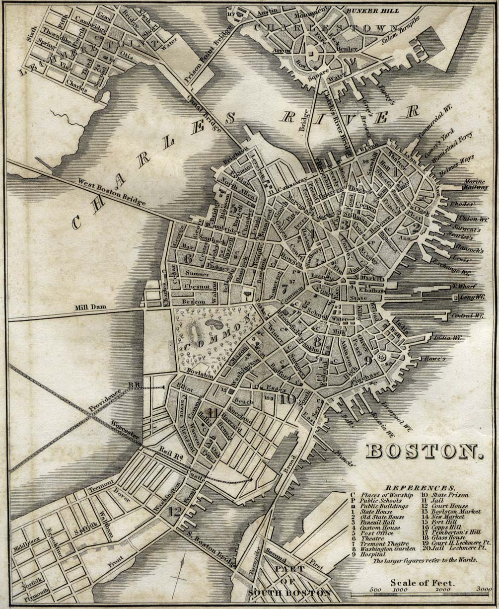
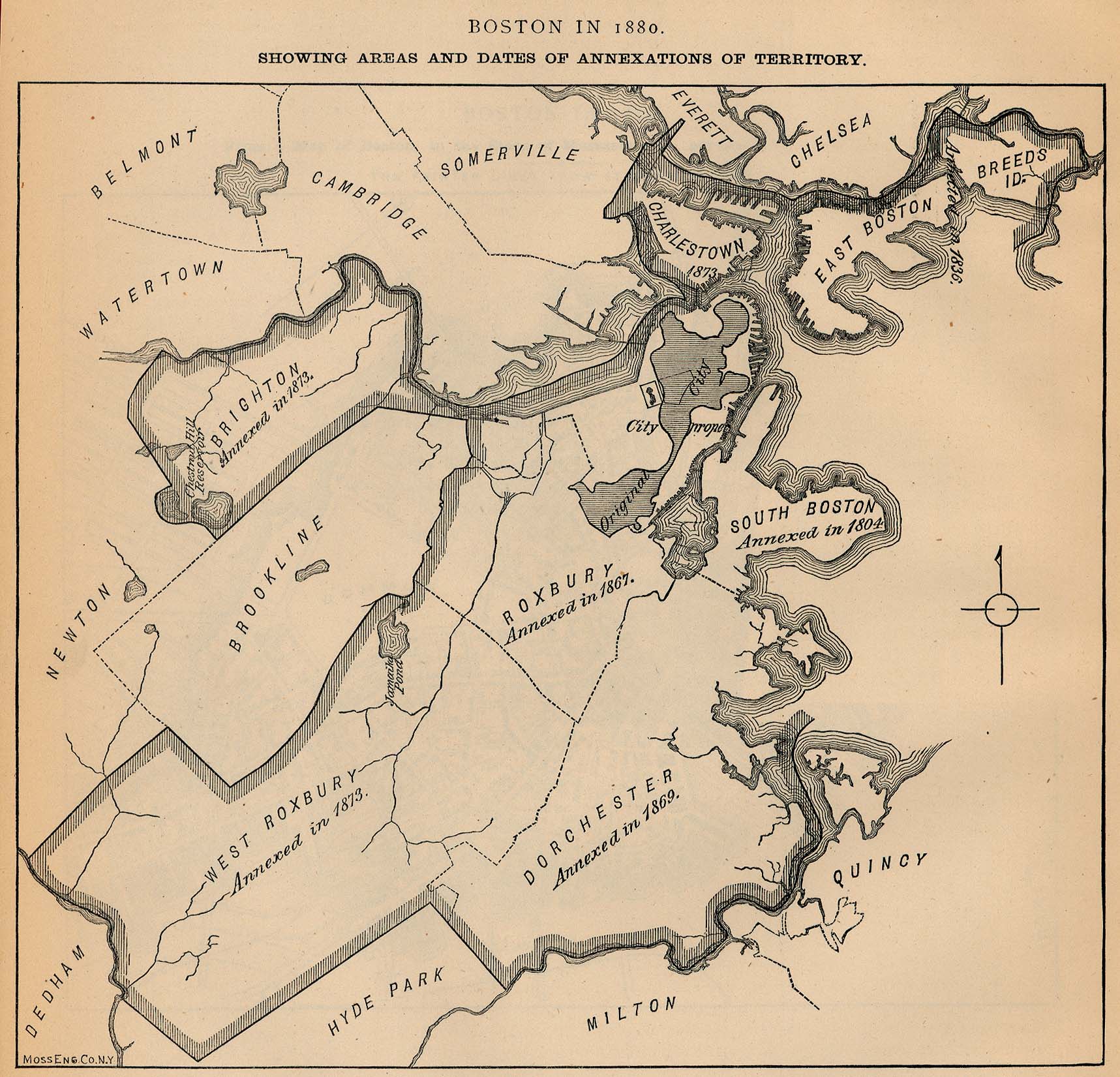
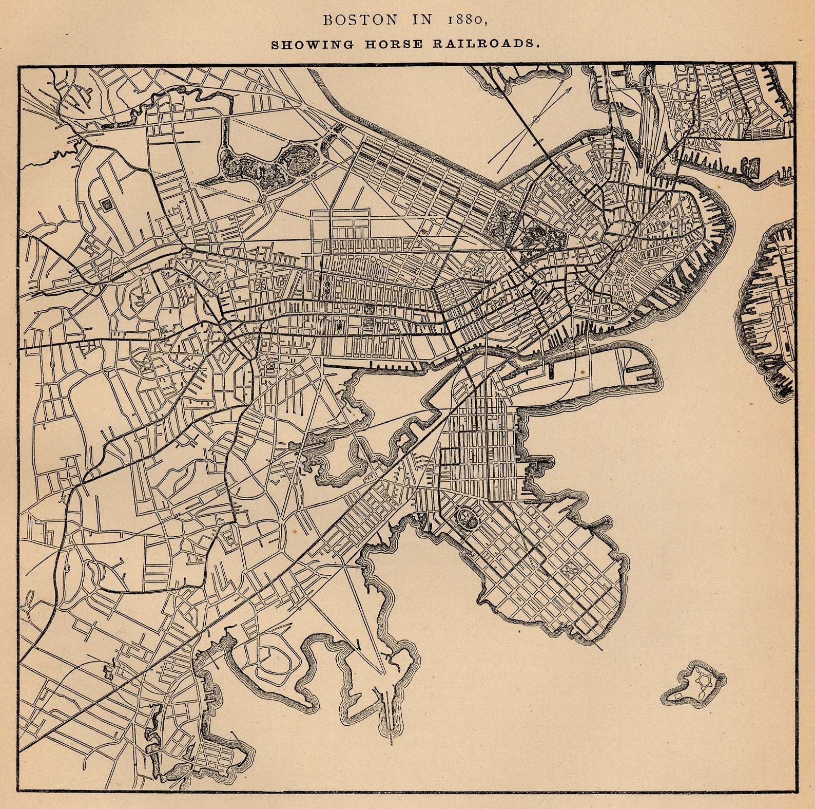
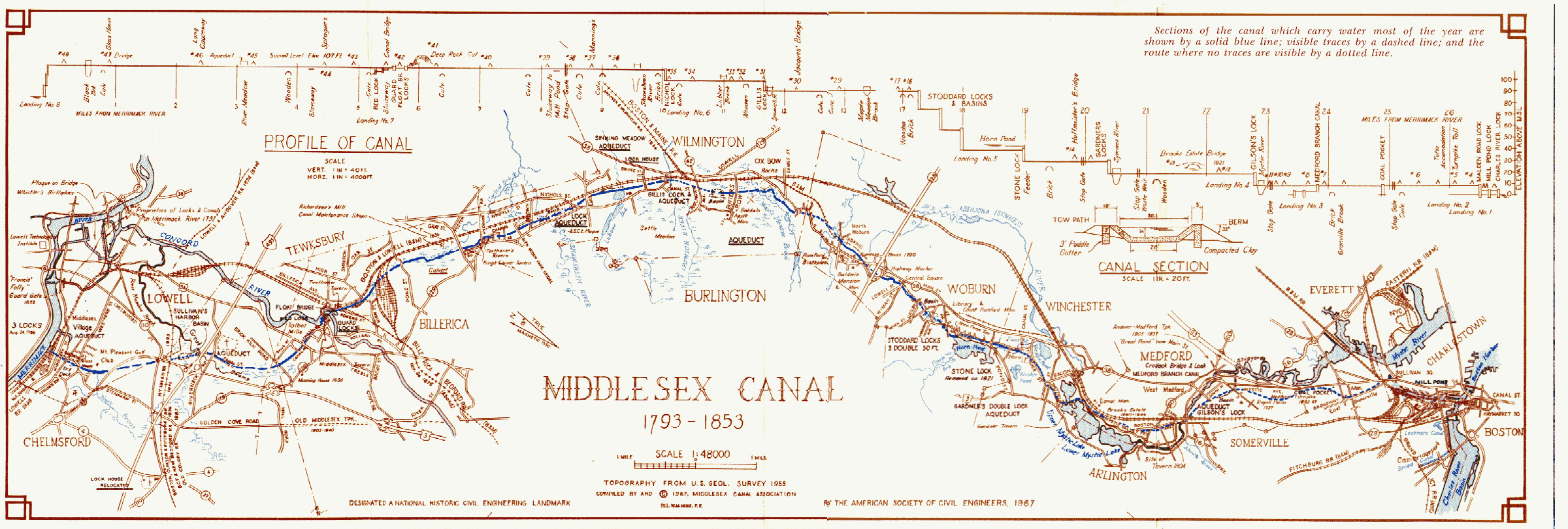
- Historical Urban Atlases of Boston at the Boston Public Library
- USGS Historical Topographic Map Explorer